1960s Maps of Arcola, Mississippi
Explore 2 historic maps of Arcola from the 1960s. These maps offer a rare glimpse into what life looked like during the 1960s — showing old roads, neighborhoods, homes, and landmarks that have changed or disappeared over time.
Whether you're researching your family's past, planning a metal detecting trip, or studying how Arcola's landscape evolved across the 1960s, these high-resolution maps are a powerful tool for exploring the history of this region.
- Focus on a specific era: All maps on this page are from the 1960s, giving you a focused view of this time period.
- See what’s changed: Compare century-old streets, trails, and buildings to today's modern landscape using overlays and satellite layers.
- Research with precision: Use these maps for genealogy, historical research, land use analysis, or educational projects.
- View, download, or print: Maps are fully viewable online in high resolution, and can be downloaded or printed for your own records.
Start exploring Arcola's history through authentic maps from the 1960s. This is your window into the past.
Arcola, MS maps
(2)- 1967 Map of Arcola, 1968 Print
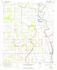 1967 Arcola1968 Print · USGSThe Mississippi Delta's intricate landscape of winding bayous and rail lines is captured here in the late sixties. Trace the local genealogy and land use through landmarks like Arcola, the ILLINOIS CENTRAL railroad, and Morning Star Ch.2 unique versions available
 - 1969 Map of Tralake
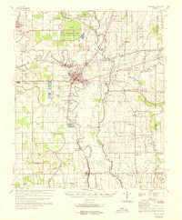 1969 Tralake1969 Print · USGSWashington and Sunflower Counties in the late sixties reveal a landscape of deep-rooted agriculture and small rail-stop communities. Genealogists can trace family landmarks and rural congregations at Greenlawn Memorial Gardens, St Johns Chapel, and the settlement of Bourbon.
End of results
Showing maps 1-2 of 2
Top cities near Arcola
- Greenville historical maps
- Indianola historical maps
- Leland historical maps
- Hollandale historical maps
- Metcalfe historical maps
Frequently asked questions
- What are the different types of historical maps available for Arcola?
- What is the oldest map of Arcola?
- Where can I purchase historical maps of Arcola for my home or office?
- Where can I download high-res historical maps of Arcola?
- Are there historical topographic maps available for Arcola?
- Is there historical aerial imagery available for Arcola?
- Where are historical maps of Arcola sourced from?