1970s Maps of Shell Knob, Missouri
Explore 1 historic maps of Shell Knob from the 1970s. These maps offer a rare glimpse into what life looked like during the 1970s — showing old roads, neighborhoods, homes, and landmarks that have changed or disappeared over time.
Whether you're researching your family's past, planning a metal detecting trip, or studying how Shell Knob's landscape evolved across the 1970s, these high-resolution maps are a powerful tool for exploring the history of this region.
- Focus on a specific era: All maps on this page are from the 1970s, giving you a focused view of this time period.
- See what’s changed: Compare century-old streets, trails, and buildings to today's modern landscape using overlays and satellite layers.
- Research with precision: Use these maps for genealogy, historical research, land use analysis, or educational projects.
- View, download, or print: Maps are fully viewable online in high resolution, and can be downloaded or printed for your own records.
Start exploring Shell Knob's history through authentic maps from the 1970s. This is your window into the past.
Shell Knob, MO maps
(1)- 1974 Map of Shell Knob, 1977 Print
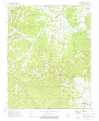 1974 Shell Knob1977 Print · USGSThe Ozark plateau of southwest Missouri is captured here in the mid-1970s, showcasing a landscape of national forest and scattered mountain settlements. Genealogists can locate several family cemeteries like Doughty Cem and Snyder Cem alongside rural hubs such as Hill City and Lohmer.2 unique versions available
End of results
Showing maps 1-1 of 1
Top cities near Shell Knob
- Cassville historical maps
- Kimberling City historical maps
- Eureka Springs historical maps
- Galena historical maps
- Branson West historical maps
- Oak Grove historical maps
See more
Frequently asked questions
- What are the different types of historical maps available for Shell Knob?
- What is the oldest map of Shell Knob?
- Where can I purchase historical maps of Shell Knob for my home or office?
- Where can I download high-res historical maps of Shell Knob?
- Are there historical topographic maps available for Shell Knob?
- Is there historical aerial imagery available for Shell Knob?
- Where are historical maps of Shell Knob sourced from?