1900s (20th Century) Maps of Knobby, Missouri
Explore 9 historic maps of Knobby from the 1900s (20th Century). These maps offer a rare glimpse into what life looked like during the 1900s — showing old roads, neighborhoods, homes, and landmarks that have changed or disappeared over time.
Whether you're researching your family's past, planning a metal detecting trip, or studying how Knobby's landscape evolved across the 1900s, these high-resolution maps are a powerful tool for exploring the history of this region.
- Focus on a specific era: All maps on this page are from the 1900s, giving you a focused view of this time period.
- See what’s changed: Compare century-old streets, trails, and buildings to today's modern landscape using overlays and satellite layers.
- Research with precision: Use these maps for genealogy, historical research, land use analysis, or educational projects.
- View, download, or print: Maps are fully viewable online in high resolution, and can be downloaded or printed for your own records.
Start exploring Knobby's history through authentic maps from the 1900s. This is your window into the past.
Knobby, MO maps
(9)- 1935 Map of Knobby Creek
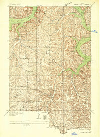 1935 Knobby Creek1935 Print · USGSThe northern Lake of the Ozarks shoreline and its surrounding uplands appear here in the mid-1930s as the reservoir era began. Genealogists can trace rural school districts like Olive Branch School and Nickel Hill School or locate family sites near Dority Cem and Sagrada.2 unique versions available
 - 1947 Map of Jefferson City, 1949 Print
 1947 Jefferson City1949 Print · USGSCentral Missouri and the northern Ozarks come into focus in this late 1940s survey of the river-and-rail landscape. Genealogists and historians can trace the growth of Jefferson City and Sedalia or locate family roots near Bagnell Dam and the Lake of the Ozarks.
 - 1954 Map of Jefferson City
 1954 Jefferson City1954 Print · USGSCentral Missouri in the early postwar years showcases a landscape defined by the winding Lake of the Ozarks and the state capital at Jefferson City. Researchers can trace the mid-century rail networks of the Missouri Pacific RR and locate rural communities like Tuscumbia, St Elizabeth, and St Anthony.2 unique versions available
 - 1955 Map of Jefferson City, 1967 Print
 1955 Jefferson City1967 Print · USGSCentral Missouri in the mid-fifties is defined by the winding Missouri River and the expanding reach of Lake of the Ozarks. Researchers can trace the rail corridors of the Missouri Pacific or locate the early footprint of Whiteman AFB and Jefferson City.4 unique versions available
 - 1958 Map of Jefferson City
 1958 Jefferson City1958 Print · USGSCentral Missouri in the late fifties shows a region transforming through the growth of Whiteman Air Force Base and the Lake of the Ozarks. Researchers can trace rail lines like the Missouri Pacific or find family roots at Enloe Cemetery and Mount Pleasant Cem.
 - 1959 Map of Jefferson City
 1959 Jefferson City1959 Print · USGSCentral Missouri is captured during the mid-fifties as the river economy and rail networks like the Missouri Pacific met the rise of the automobile. Local researchers can trace family landmarks and rural infrastructure from the Lake of the Ozarks up to Providence Cemetery and Knob Noster State Park.
 - 1959 Map of Knobby, 1960 Print
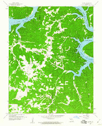 1959 Knobby1960 Print · USGSCamden County and the surrounding Ozarks are captured here in the late fifties, showing the intricate shoreline and rural communities of the region. Researchers can trace family roots at Lick Creek Church, the Dandy Cemetery, and small crossroads like Sagrada.2 unique versions available
 - 1983 Map of Knobby
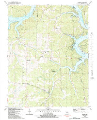 1983 Knobby1983 Print · USGSThe northern Ozarks landscape is captured here in the early 1980s, where the winding Lake of the Ozarks meets rugged Missouri ridges. Genealogists and hikers can trace old family landmarks like Dority Cemetery, Adkins Cave, and the small settlement of Knobby.
 - 1983 Map of Harry S Truman Reservoir, 1984 Print
 1983 Harry S Truman Reservoir1984 Print · USGSBenton and Henry counties center on the vast Harry S Truman Reservoir in the early 1980s as the landscape adapted to its new shoreline. Genealogists and historians can trace old river crossings like Bledsoe Ferry, local landmarks like Mt Zion Ch, and unique settlements such as Tightwad.
End of results
Showing maps 1-9 of 9
Top cities near Knobby
- Hermitage historical maps
- Macks Creek historical maps
- Cross Timbers historical maps
- Preston historical maps
- Climax Springs historical maps
Frequently asked questions
- What are the different types of historical maps available for Knobby?
- What is the oldest map of Knobby?
- Where can I purchase historical maps of Knobby for my home or office?
- Where can I download high-res historical maps of Knobby?
- Are there historical topographic maps available for Knobby?
- Is there historical aerial imagery available for Knobby?
- Where are historical maps of Knobby sourced from?