1960s Maps of Hallsville, Missouri
Explore 3 historic maps of Hallsville from the 1960s. These maps offer a rare glimpse into what life looked like during the 1960s — showing old roads, neighborhoods, homes, and landmarks that have changed or disappeared over time.
Whether you're researching your family's past, planning a metal detecting trip, or studying how Hallsville's landscape evolved across the 1960s, these high-resolution maps are a powerful tool for exploring the history of this region.
- Focus on a specific era: All maps on this page are from the 1960s, giving you a focused view of this time period.
- See what’s changed: Compare century-old streets, trails, and buildings to today's modern landscape using overlays and satellite layers.
- Research with precision: Use these maps for genealogy, historical research, land use analysis, or educational projects.
- View, download, or print: Maps are fully viewable online in high resolution, and can be downloaded or printed for your own records.
Start exploring Hallsville's history through authentic maps from the 1960s. This is your window into the past.
Hallsville, MO maps
(3)- 1960 Map of Moberly
 1960 Moberly1960 Print · USGSCentral Missouri comes alive in the mid-twentieth century as a bustling network of river towns and significant rail corridors. Genealogists and historians can trace the paths of the Wabash RR through Moberly or explore the riverfronts of Lexington and Brunswick.
 - 1969 Map of Centralia, 1971 Print
 1969 Centralia1971 Print · USGSThe mid-Missouri rail hub of Centralia is captured here at the close of the 1960s as it straddles the Audrain and Boone county line. Researchers can trace the town's growth along the Norfolk and Western tracks or locate landmarks like Sunnydale Academy and Fax West Cem.3 unique versions available
 - 1969 Map of Hallsville, 1971 Print
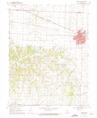
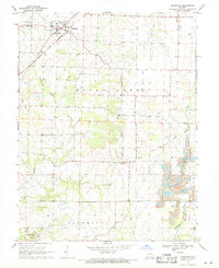 1969 Hallsville1971 Print · USGSNorthern Boone County's rural landscape is captured here in the late sixties, centered on the railroad town of Hallsville. Genealogists and historians can locate family landmarks like Stephens Cem, Mt Hope Ch, and the Twomile Prairie Sch.2 unique versions available
End of results
Showing maps 1-3 of 3
Top cities near Hallsville
- Columbia historical maps
- Centralia historical maps
- Sturgeon historical maps
- Clark historical maps
- Renick historical maps
- Harrisburg historical maps
Frequently asked questions
- What are the different types of historical maps available for Hallsville?
- What is the oldest map of Hallsville?
- Where can I purchase historical maps of Hallsville for my home or office?
- Where can I download high-res historical maps of Hallsville?
- Are there historical topographic maps available for Hallsville?
- Is there historical aerial imagery available for Hallsville?
- Where are historical maps of Hallsville sourced from?