1980s Maps of Sparta, Missouri
Explore 2 historic maps of Sparta from the 1980s. These maps offer a rare glimpse into what life looked like during the 1980s — showing old roads, neighborhoods, homes, and landmarks that have changed or disappeared over time.
Whether you're researching your family's past, planning a metal detecting trip, or studying how Sparta's landscape evolved across the 1980s, these high-resolution maps are a powerful tool for exploring the history of this region.
- Focus on a specific era: All maps on this page are from the 1980s, giving you a focused view of this time period.
- See what’s changed: Compare century-old streets, trails, and buildings to today's modern landscape using overlays and satellite layers.
- Research with precision: Use these maps for genealogy, historical research, land use analysis, or educational projects.
- View, download, or print: Maps are fully viewable online in high resolution, and can be downloaded or printed for your own records.
Start exploring Sparta's history through authentic maps from the 1980s. This is your window into the past.
Sparta, MO maps
(2)- 1980 Map of St. Joseph South, 1981 Print
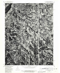 1980 St. Joseph South1981 Print · USGSThe southern fringes of St Joseph and the surrounding Buchanan County farmlands are seen here in the early eighties. Genealogists and local historians can trace the rural landscape around Saxton and Willow Brook or follow the path of Contrary Creek.
 - 1986 Map of Saint Joseph
 1986 Saint Joseph1986 Print · USGSNorthwest Missouri thrived as a regional transportation and educational hub during the mid-eighties, centered on the historic river city of Saint Joseph. Researchers can locate specific local landmarks like Burlington Cemetery, Pigeon Hill Church, and the winding Pony Express Trail.2 unique versions available
End of results
Showing maps 1-2 of 2
Top cities near Sparta
- Saint Joseph historical maps
- Weston historical maps
- Wathena historical maps
- Elwood historical maps
- Agency historical maps
- Edgerton historical maps
See more
Frequently asked questions
- What are the different types of historical maps available for Sparta?
- What is the oldest map of Sparta?
- Where can I purchase historical maps of Sparta for my home or office?
- Where can I download high-res historical maps of Sparta?
- Are there historical topographic maps available for Sparta?
- Is there historical aerial imagery available for Sparta?
- Where are historical maps of Sparta sourced from?