1920s Maps of Caldwell County, Missouri
Explore 4 historic maps of Caldwell County from the 1920s. These maps offer a rare glimpse into what life looked like during the 1920s — showing old roads, neighborhoods, homes, and landmarks that have changed or disappeared over time.
Whether you're researching your family's past, planning a metal detecting trip, or studying how Caldwell County's landscape evolved across the 1920s, these high-resolution maps are a powerful tool for exploring the history of this region.
- Focus on a specific era: All maps on this page are from the 1920s, giving you a focused view of this time period.
- See what’s changed: Compare century-old streets, trails, and buildings to today's modern landscape using overlays and satellite layers.
- Research with precision: Use these maps for genealogy, historical research, land use analysis, or educational projects.
- View, download, or print: Maps are fully viewable online in high resolution, and can be downloaded or printed for your own records.
Start exploring Caldwell County's history through authentic maps from the 1920s. This is your window into the past.
Caldwell County, MO maps
(4)- 1922 Map of Gallatin
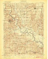 1922 Gallatin1922 Print · USGSDaviess and Caldwell Counties are shown here during the early twenties, when the Grand River and major railroads drove the local economy. Genealogists can trace hundreds of rural family sites anchored by Everly Cemetery, Centenary Church, and schools like Calfpen School.2 unique versions available
 - 1924 Map of Polo
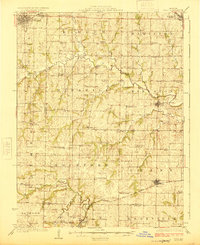 1924 Polo1924 Print · USGSCaldwell County rural life in the early twenties is centered around a dense network of school districts and small rail towns. Genealogists can trace family roots through dozens of local landmarks like Kendall Church, Yankee Ridge School, and the Stoner Bridge.2 unique versions available
 - 1924 Map of Braymer
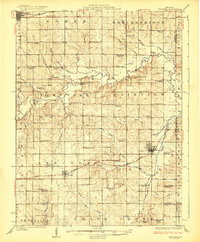 1924 Braymer1924 Print · USGSNorthwest Missouri's agricultural heartland is documented here in the early twenties, showing a landscape defined by the railroad and a dense grid of rural schoolhouses. Genealogists can locate specific family landmarks like Brown Jug School, Hopewell Church, and the Gould Farm Bridge.3 unique versions available
 - 1924 Map of Winston
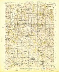 1924 Winston1924 Print · USGSDaviess and Caldwell counties are shown here in the 1920s, featuring a dense network of rural schools and multiple railroad junctions. Researchers can trace family history through landmarks like Roasting Ear School, Wamsley Church, and the town of Winston.3 unique versions available
End of results
Showing maps 1-4 of 4
Top cities of Caldwell County
- Hamilton historical maps
- Braymer historical maps
- Polo historical maps
- Breckenridge historical maps
- Mirabile historical maps
- Kingston historical maps
See more
Frequently asked questions
- What are the different types of historical maps available for Caldwell County?
- What is the oldest map of Caldwell County?
- Where can I purchase historical maps of Caldwell County for my home or office?
- Where can I download high-res historical maps of Caldwell County?
- Are there historical topographic maps available for Caldwell County?
- Is there historical aerial imagery available for Caldwell County?
- Where are historical maps of Caldwell County sourced from?