1940s Maps of South Van Buren, Missouri
Explore 2 historic maps of South Van Buren from the 1940s. These maps offer a rare glimpse into what life looked like during the 1940s — showing old roads, neighborhoods, homes, and landmarks that have changed or disappeared over time.
Whether you're researching your family's past, planning a metal detecting trip, or studying how South Van Buren's landscape evolved across the 1940s, these high-resolution maps are a powerful tool for exploring the history of this region.
- Focus on a specific era: All maps on this page are from the 1940s, giving you a focused view of this time period.
- See what’s changed: Compare century-old streets, trails, and buildings to today's modern landscape using overlays and satellite layers.
- Research with precision: Use these maps for genealogy, historical research, land use analysis, or educational projects.
- View, download, or print: Maps are fully viewable online in high resolution, and can be downloaded or printed for your own records.
Start exploring South Van Buren's history through authentic maps from the 1940s. This is your window into the past.
South Van Buren, MO maps
(2)- 1944 Map of Van Buren, 1960 Print
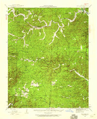 1944 Van Buren1960 Print · USGSThe Ozark hill country of Carter and Shannon counties appears here in the mid-1940s. Researchers can trace the St Louis San Francisco rail line or locate rural sites like Pleasant Site Cem, Chicopee, and the Bristoll Sch.2 unique versions available
 - 1946 Map of Van Buren
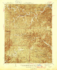 1946 Van Buren1946 Print · USGSThe Ozark foothills of Carter County are shown here in the 1940s, dominated by the winding Current River and the sprawling Clark National Forest. Genealogists and hikers can trace the footprints of rural communities at Wilderness, Bristol Church, and Rinnard School.2 unique versions available
End of results
Showing maps 1-2 of 2
Top cities near South Van Buren
Frequently asked questions
- What are the different types of historical maps available for South Van Buren?
- What is the oldest map of South Van Buren?
- Where can I purchase historical maps of South Van Buren for my home or office?
- Where can I download high-res historical maps of South Van Buren?
- Are there historical topographic maps available for South Van Buren?
- Is there historical aerial imagery available for South Van Buren?
- Where are historical maps of South Van Buren sourced from?