1950s Maps of Clay County, Missouri
Explore 11 historic maps of Clay County from the 1950s. These maps offer a rare glimpse into what life looked like during the 1950s — showing old roads, neighborhoods, homes, and landmarks that have changed or disappeared over time.
Whether you're researching your family's past, planning a metal detecting trip, or studying how Clay County's landscape evolved across the 1950s, these high-resolution maps are a powerful tool for exploring the history of this region.
- Focus on a specific era: All maps on this page are from the 1950s, giving you a focused view of this time period.
- See what’s changed: Compare century-old streets, trails, and buildings to today's modern landscape using overlays and satellite layers.
- Research with precision: Use these maps for genealogy, historical research, land use analysis, or educational projects.
- View, download, or print: Maps are fully viewable online in high resolution, and can be downloaded or printed for your own records.
Start exploring Clay County's history through authentic maps from the 1950s. This is your window into the past.
Clay County, MO maps
(11)- 1950 Map of Kansas City
 1950 Kansas City1950 Print · USGSMid-century Kansas and Missouri are captured here during a period of industrial growth and shifting transportation. Genealogists and historians can trace rail lines like the Wabash RR or locate ancestral homes near the Potawatomi Indian Reservation and Horton.
 - 1950 Map of Nashua
 1950 Nashua1950 Print · USGSClay and Platte Counties are captured here in the late 1940s, showing a landscape of rural school districts and small crossroads towns. Researchers can trace family ties through community hubs like Nashua, Mt Olivet Church, and the Lone Star School.
 - 1950 Map of Smithville
 1950 Smithville1950 Print · USGSThe rural borderlands of Platte, Clay, and Clinton counties are shown here just after the war, defined by the winding Platte River and a network of small farm towns. Researchers can trace the locations of dozens of vanished schools and cemeteries, from the Masonic Cemetery to the South Gale School and the historic Covered Bridge.2 unique versions available
 - 1951 Map of Smithville
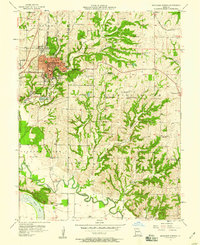
 1951 Smithville1951 Print · USGSNorth of Kansas City in the early 1950s, this area shows a landscape of river-valley farms and small rural settlements. Researchers can locate numerous one-room schoolhouses like Rocky Point School and trace family-named landmarks such as Reed Cemetery and Rice Bridge.2 unique versions available
 - 1951 Map of North Kansas City
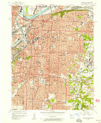
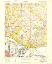 1951 North Kansas City1951 Print · USGSThe Kansas City riverfront was a bustling hub of rail and aviation activity in the early fifties. Genealogists and local historians can trace family roots through landmarks like Quindaro, the Dunbar School, and the historic Antioch Church.2 unique versions available
 - 1954 Map of Kansas City
 1954 Kansas City1954 Print · USGSThe Missouri-Kansas borderlands flourished in the post-war era as river commerce and rail networks converged at the Missouri River. Genealogists and historians can trace the foundations of Kansas City and smaller rural hubs like Hiawatha or Sabetha.
 - 1956 Map of Kansas City, 1967 Print
 1956 Kansas City1967 Print · USGSThe Kansas-Missouri border region thrived during the mid-fifties, centered on the growing metropolitan cores and the busy river valleys. Researchers can trace the layout of significant government sites like Fort Leavenworth and the Lake City Army Ammunition Plant.4 unique versions available
 - 1957 Map of Independence, 1958 Print
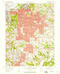 1957 Independence1958 Print · USGSIndependence and the eastern edge of Kansas City are shown here at a peak of mid-century development. Researchers can locate hundreds of local landmarks, from the Harry S Truman Memorial Library to the sprawling Oil Refinery and the Washington Cemetery.
 - 1957 Map of Lawson, 1958 Print
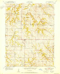
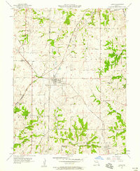 1957 Lawson1958 Print · USGSMid-century Lawson and Vibbard sit at the junction of two major rail lines as they cut through the tri-county corner of Clay, Clinton, and Ray. Family historians can locate rural landmarks like Canaan Hill Ch, Franklin Sch, and the Elmira Camp near the Crooked River.2 unique versions available
 - 1957 Map of Excelsior Springs, 1958 Print
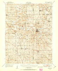
 1957 Excelsior Springs1958 Print · USGSThe resort city of Excelsior Springs and the surrounding Clay County farmland are shown here in the mid-fifties. Researchers can locate numerous local landmarks including Crown Hill Cem, rural sites like Miltondale, and the Excelsior Institute medical facilities.2 unique versions available
 - 1957 Map of Kansas City, 1958 Print
 1957 Kansas City1958 Print · USGSKansas City at the dawn of the space age shows a bustling metropolitan hub still centered on its grand river crossings and rail terminals. Trace the city's mid-century footprint from the iconic Liberty Memorial and Union Station to the legendary Municipal Stadium and Swope Park.
End of results
Showing maps 1-11 of 11
Top cities of Clay County
- Liberty historical maps
- Gladstone historical maps
- Excelsior Springs historical maps
- Kearney historical maps
- Smithville historical maps
- North Kansas City historical maps
See more
Frequently asked questions
- What are the different types of historical maps available for Clay County?
- What is the oldest map of Clay County?
- Where can I purchase historical maps of Clay County for my home or office?
- Where can I download high-res historical maps of Clay County?
- Are there historical topographic maps available for Clay County?
- Is there historical aerial imagery available for Clay County?
- Where are historical maps of Clay County sourced from?