1990s Maps of Ranger, Missouri
Explore 1 historic maps of Ranger from the 1990s. These maps offer a rare glimpse into what life looked like during the 1990s — showing old roads, neighborhoods, homes, and landmarks that have changed or disappeared over time.
Whether you're researching your family's past, planning a metal detecting trip, or studying how Ranger's landscape evolved across the 1990s, these high-resolution maps are a powerful tool for exploring the history of this region.
- Focus on a specific era: All maps on this page are from the 1990s, giving you a focused view of this time period.
- See what’s changed: Compare century-old streets, trails, and buildings to today's modern landscape using overlays and satellite layers.
- Research with precision: Use these maps for genealogy, historical research, land use analysis, or educational projects.
- View, download, or print: Maps are fully viewable online in high resolution, and can be downloaded or printed for your own records.
Start exploring Ranger's history through authentic maps from the 1990s. This is your window into the past.
Ranger, MO maps
(1)- 1992 Map of Rhyse, 1995 Print
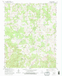 1992 Rhyse1995 Print · USGSThe rural Ozark highlands of Dent County are captured here during the 1990s, revealing a landscape of family cemeteries and remote hollows. Genealogists and local historians can trace legacy sites like Robnett Cem or find the Lookout Tower Zion near the Montauk State Public Hunting Area.
End of results
Showing maps 1-1 of 1
Top cities near Ranger
- Salem historical maps
- Sherrill historical maps
- Houston historical maps
- Licking historical maps
- Raymondville historical maps
- Edgar Springs historical maps
Frequently asked questions
- What are the different types of historical maps available for Ranger?
- What is the oldest map of Ranger?
- Where can I purchase historical maps of Ranger for my home or office?
- Where can I download high-res historical maps of Ranger?
- Are there historical topographic maps available for Ranger?
- Is there historical aerial imagery available for Ranger?
- Where are historical maps of Ranger sourced from?