1940s Maps of Salem, Missouri
Explore 3 historic maps of Salem from the 1940s. These maps offer a rare glimpse into what life looked like during the 1940s — showing old roads, neighborhoods, homes, and landmarks that have changed or disappeared over time.
Whether you're researching your family's past, planning a metal detecting trip, or studying how Salem's landscape evolved across the 1940s, these high-resolution maps are a powerful tool for exploring the history of this region.
- Focus on a specific era: All maps on this page are from the 1940s, giving you a focused view of this time period.
- See what’s changed: Compare century-old streets, trails, and buildings to today's modern landscape using overlays and satellite layers.
- Research with precision: Use these maps for genealogy, historical research, land use analysis, or educational projects.
- View, download, or print: Maps are fully viewable online in high resolution, and can be downloaded or printed for your own records.
Start exploring Salem's history through authentic maps from the 1940s. This is your window into the past.
Salem, MO maps
(3)- 1941 Map of Salem, 1956 Print
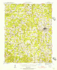 1941 Salem1956 Print · USGSThe Ozark highlands surrounding Salem are captured here in the early 1940s, showing a landscape defined by small farms and local industry. Researchers can trace dozens of rural landmarks, from the County Farm and Lennox Bank to vanished schools like Oak Ridge Sch and Pleasant View Sch.2 unique versions available
 - 1945 Map of Salem
 1945 Salem1945 Print · USGSDent County's rural character and rail connections are preserved here in the mid-1940s. Genealogists can trace family lines through numerous landmarks like Karns Cem, Oakland Sch, and the St. Louis-San Francisco RR at Salem.2 unique versions available
 - 1949 Map of Rolla, 1950 Print
 1949 Rolla1950 Print · USGSThe Missouri Ozarks are captured here just after the war, showing a landscape of deep river valleys and emerging reservoir projects. Genealogists and historians can trace the mining towns of Bonne Terre and Potosi or follow the early route of U.S. Highway 66.
End of results
Showing maps 1-3 of 3
Frequently asked questions
- What are the different types of historical maps available for Salem?
- What is the oldest map of Salem?
- Where can I purchase historical maps of Salem for my home or office?
- Where can I download high-res historical maps of Salem?
- Are there historical topographic maps available for Salem?
- Is there historical aerial imagery available for Salem?
- Where are historical maps of Salem sourced from?