1980s Maps of Pohlman Mill, Missouri
Explore 2 historic maps of Pohlman Mill from the 1980s. These maps offer a rare glimpse into what life looked like during the 1980s — showing old roads, neighborhoods, homes, and landmarks that have changed or disappeared over time.
Whether you're researching your family's past, planning a metal detecting trip, or studying how Pohlman Mill's landscape evolved across the 1980s, these high-resolution maps are a powerful tool for exploring the history of this region.
- Focus on a specific era: All maps on this page are from the 1980s, giving you a focused view of this time period.
- See what’s changed: Compare century-old streets, trails, and buildings to today's modern landscape using overlays and satellite layers.
- Research with precision: Use these maps for genealogy, historical research, land use analysis, or educational projects.
- View, download, or print: Maps are fully viewable online in high resolution, and can be downloaded or printed for your own records.
Start exploring Pohlman Mill's history through authentic maps from the 1980s. This is your window into the past.
Pohlman Mill, MO maps
(2)- 1980 Map of Moselle, 1982 Print
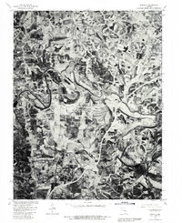 1980 Moselle1982 Print · USGSFranklin County's rolling river valleys and agricultural plateaus are captured in detail during the early 1980s. Researchers can trace the meandering Bourbeuse River and locate family lands near Moselle, Villa Ridge, and Gildehouse.
 - 1985 Map of Festus, 1987 Print
 1985 Festus1987 Print · USGSThe Mississippi River corridor and Ozark foothills appear here in the mid-1980s, documenting a landscape of industrial river towns and forest preserves. Trace the development of Festus, Crystal City, and De Soto or locate sites like Mastodon State Park.
End of results
Showing maps 1-2 of 2
Top cities near Pohlman Mill
- Washington historical maps
- Union historical maps
- Pacific historical maps
- Sullivan historical maps
- Saint Clair historical maps
- Gray Summit historical maps
See more
Frequently asked questions
- What are the different types of historical maps available for Pohlman Mill?
- What is the oldest map of Pohlman Mill?
- Where can I purchase historical maps of Pohlman Mill for my home or office?
- Where can I download high-res historical maps of Pohlman Mill?
- Are there historical topographic maps available for Pohlman Mill?
- Is there historical aerial imagery available for Pohlman Mill?
- Where are historical maps of Pohlman Mill sourced from?