1990s Maps of Brentwood, Springfield
Explore 2 historic maps of Brentwood from the 1990s. These maps offer a rare glimpse into what life looked like during the 1990s — showing old roads, neighborhoods, homes, and landmarks that have changed or disappeared over time.
Whether you're researching your family's past, planning a metal detecting trip, or studying how Brentwood's landscape evolved across the 1990s, these high-resolution maps are a powerful tool for exploring the history of this region.
- Focus on a specific era: All maps on this page are from the 1990s, giving you a focused view of this time period.
- See what’s changed: Compare century-old streets, trails, and buildings to today's modern landscape using overlays and satellite layers.
- Research with precision: Use these maps for genealogy, historical research, land use analysis, or educational projects.
- View, download, or print: Maps are fully viewable online in high resolution, and can be downloaded or printed for your own records.
Start exploring Brentwood's history through authentic maps from the 1990s. This is your window into the past.
Brentwood, Springfield maps
(2)- 1996 Map of Galloway, 2000 Print
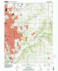 1996 Galloway2000 Print · USGSGreene County experiences significant suburban growth in the late nineties as development extends east from the city. Genealogists and historians can trace family-named sites like Kinser Chapel, locate the Flying Bar H Landing Strip, and follow the Burlington Northern railroad through Galloway.
 - 1996 Map of Springfield, 2000 Print
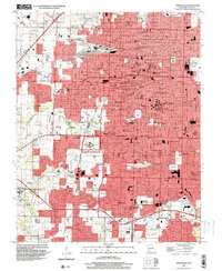 1996 Springfield2000 Print · USGSSpringfield and Greene County at the turn of the millennium show a city shaped by major institutions and growing suburbs. Researchers can trace the grounds of Southwest Missouri State University, Springfield National Cem, and the historic community of Nichols.
End of results
Showing maps 1-2 of 2
Frequently asked questions
- What are the different types of historical maps available for Brentwood?
- What is the oldest map of Brentwood?
- Where can I purchase historical maps of Brentwood for my home or office?
- Where can I download high-res historical maps of Brentwood?
- Are there historical topographic maps available for Brentwood?
- Is there historical aerial imagery available for Brentwood?
- Where are historical maps of Brentwood sourced from?