1930s Maps of High Ridge Township, Missouri
Explore 5 historic maps of High Ridge Township from the 1930s. These maps offer a rare glimpse into what life looked like during the 1930s — showing old roads, neighborhoods, homes, and landmarks that have changed or disappeared over time.
Whether you're researching your family's past, planning a metal detecting trip, or studying how High Ridge Township's landscape evolved across the 1930s, these high-resolution maps are a powerful tool for exploring the history of this region.
- Focus on a specific era: All maps on this page are from the 1930s, giving you a focused view of this time period.
- See what’s changed: Compare century-old streets, trails, and buildings to today's modern landscape using overlays and satellite layers.
- Research with precision: Use these maps for genealogy, historical research, land use analysis, or educational projects.
- View, download, or print: Maps are fully viewable online in high resolution, and can be downloaded or printed for your own records.
Start exploring High Ridge Township's history through authentic maps from the 1930s. This is your window into the past.
High Ridge Township, MO maps
(5)- 1930 Map of Pacific SE
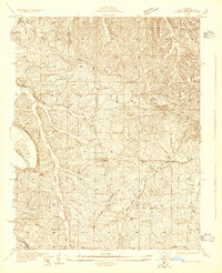 1930 Pacific SE1930 Print · USGSJefferson County rural life in the early 1930s is captured here through its network of country schoolhouses and river valleys. Researchers can trace historic routes like Le May Ferry Road and find old settlements such as Belews and Goldman.2 unique versions available
 - 1931 Map of Manchester SE
 1931 Manchester SE1931 Print · USGSSt. Louis County and Jefferson County were still largely defined by the river and rail lines during the early 1930s. Researchers can trace the early layout of Times Beach or locate family-history landmarks like the Rankin Cem and Oak Ridge Sch.
 - 1931 Map of Pacific NE
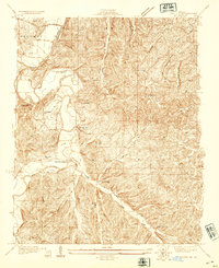 1931 Pacific NE1931 Print · USGSJefferson County was a land of river bends and rural schools in the early thirties. Local historians can trace the foundations of communities at Byrnes Mill and House Springs, or locate old schoolhouse sites like Whiteoak Sch and Cedar Sch.2 unique versions available
 - 1937 Map of Pacific
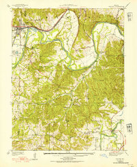 1937 Pacific1937 Print · USGSIn the late 1930s, the Meramec and Big River valleys formed a landscape of rail junctions and rural infirmaries. You can trace the rail lines at Pacific, locate the C C C Camp, or find local schools like McNamee Sch and La Barque Sch.4 unique versions available
 - 1938 Map of Cedar Hill
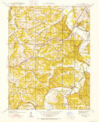 1938 Cedar Hill1938 Print · USGSJefferson County before the Second World War was a network of river-bottom mills and ridge-top schools connected by winding country roads. Genealogists can trace family footprints at Morse Mill, the MCCULLOCH FORD crossing, and rural schools like Bethlehem Sch.2 unique versions available
End of results
Showing maps 1-5 of 5
Top cities near High Ridge Township
- Chesterfield historical maps
- Wildwood historical maps
- University City historical maps
- Ballwin historical maps
- Kirkwood historical maps
- Webster Groves historical maps
See more
Top neighborhoods of High Ridge Township
- Rockford Beach historical maps
- Weber Hill historical maps
- Local historical maps
- High Ridge historical maps
- House Springs historical maps
- Byrnes Mill historical maps
See more
Frequently asked questions
- What are the different types of historical maps available for High Ridge Township?
- What is the oldest map of High Ridge Township?
- Where can I purchase historical maps of High Ridge Township for my home or office?
- Where can I download high-res historical maps of High Ridge Township?
- Are there historical topographic maps available for High Ridge Township?
- Is there historical aerial imagery available for High Ridge Township?
- Where are historical maps of High Ridge Township sourced from?