1960s Maps of Fabius, Missouri
Explore 1 historic maps of Fabius from the 1960s. These maps offer a rare glimpse into what life looked like during the 1960s — showing old roads, neighborhoods, homes, and landmarks that have changed or disappeared over time.
Whether you're researching your family's past, planning a metal detecting trip, or studying how Fabius's landscape evolved across the 1960s, these high-resolution maps are a powerful tool for exploring the history of this region.
- Focus on a specific era: All maps on this page are from the 1960s, giving you a focused view of this time period.
- See what’s changed: Compare century-old streets, trails, and buildings to today's modern landscape using overlays and satellite layers.
- Research with precision: Use these maps for genealogy, historical research, land use analysis, or educational projects.
- View, download, or print: Maps are fully viewable online in high resolution, and can be downloaded or printed for your own records.
Start exploring Fabius's history through authentic maps from the 1960s. This is your window into the past.
Fabius, MO maps
(1)- 1965 Map of Greensburg, 1966 Print
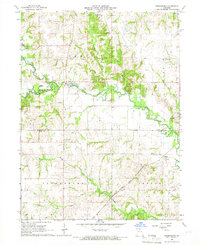 1965 Greensburg1966 Print · USGSScotland County farming communities are captured here in the mid-sixties at a time when family homesteads and rural cemeteries still defined the landscape. Genealogists can locate pioneer burial sites like Fort Donaldson Cem and Frogge Cem or trace the route of the Atchison Topeka and Santa Fe railroad.
End of results
Showing maps 1-1 of 1
Top cities near Fabius
- Memphis historical maps
- Edina historical maps
- La Belle historical maps
- Downing historical maps
- Wyaconda historical maps
- Hurdland historical maps
See more
Frequently asked questions
- What are the different types of historical maps available for Fabius?
- What is the oldest map of Fabius?
- Where can I purchase historical maps of Fabius for my home or office?
- Where can I download high-res historical maps of Fabius?
- Are there historical topographic maps available for Fabius?
- Is there historical aerial imagery available for Fabius?
- Where are historical maps of Fabius sourced from?