1960s Maps of Steffenville, Missouri
Explore 1 historic maps of Steffenville from the 1960s. These maps offer a rare glimpse into what life looked like during the 1960s — showing old roads, neighborhoods, homes, and landmarks that have changed or disappeared over time.
Whether you're researching your family's past, planning a metal detecting trip, or studying how Steffenville's landscape evolved across the 1960s, these high-resolution maps are a powerful tool for exploring the history of this region.
- Focus on a specific era: All maps on this page are from the 1960s, giving you a focused view of this time period.
- See what’s changed: Compare century-old streets, trails, and buildings to today's modern landscape using overlays and satellite layers.
- Research with precision: Use these maps for genealogy, historical research, land use analysis, or educational projects.
- View, download, or print: Maps are fully viewable online in high resolution, and can be downloaded or printed for your own records.
Start exploring Steffenville's history through authentic maps from the 1960s. This is your window into the past.
Steffenville, MO maps
(1)- 1964 Map of Newark, 1965 Print
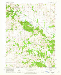 1964 Newark1965 Print · USGSNorthern Missouri farm country and the winding South Fabius River define this area in the mid-1960s. Genealogists can locate family landmarks like the Nelson Cem, Shilo Ch, and the small settlement of Steffenville.
End of results
Showing maps 1-1 of 1
Top cities near Steffenville
- Shelbyville historical maps
- La Belle historical maps
- Lewistown historical maps
- Ewing historical maps
- Knox City historical maps
- Monticello historical maps
See more
Frequently asked questions
- What are the different types of historical maps available for Steffenville?
- What is the oldest map of Steffenville?
- Where can I purchase historical maps of Steffenville for my home or office?
- Where can I download high-res historical maps of Steffenville?
- Are there historical topographic maps available for Steffenville?
- Is there historical aerial imagery available for Steffenville?
- Where are historical maps of Steffenville sourced from?