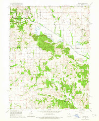
1964 Map of Newark
USGS Topo · Published 1965About this map
Newark serves as the focal point of this mid-1960s survey, positioned where the South Fabius River flows through the northern reaches of the quadrangle. The landscape is defined by the sinuous path of the river and the presence of an Old Channel, reflecting the natural shifting of waterways across the fertile bottomlands. To the south, the terrain transitions into the namesake drainage of Tiger Fork, a region characterized by its rolling character and the intersection of three county lines: Knox, Lewis, and Shelby. Rural life in this era is anchored by small community landmarks, such as Shilo Ch and Bethel Chapel, alongside burial grounds like Newark Cem and the Nelson Cem. The mapping includes distinctive red dashed lines indicating selected fence and field lines, providing an unusually detailed look at agricultural boundaries and land use patterns as they existed during the early 1960s.
Find a feature on this map
22 named features on this map. Tap any name to fly to it.
Don’t see what you’re looking for? This feature index may not catch every label — zoom into the map to look around manually.
Map Details
Editions of this 1964 Newark Map
This is the sole edition of this map. No revisions or reprints were ever made.
Other maps of this area

1903 · Kahoka
USGS Topo · 1:125,000

1903 · Palmyra
USGS Topo · 1:125,000

1903 · Edina
USGS Topo · 1:125,000

1948 · Quincy
USGS Topo · 1:250,000

1950 · Lewistown
USGS Topo · 1:24,000

1950 · La Belle
USGS Topo · 1:24,000

1951 · La Belle
USGS Topo · 1:24,000
1951 · Lewistown
USGS Topo · 1:24,000

1953 · Moberly
USGS Topo · 1:250,000

1954 · Centerville
USGS Topo · 1:250,000