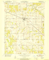
1951 Map of Lewistown
USGS Topo · Published 1951About this map
Lewistown serves as the central hub of this Lewis County landscape, situated at a vital junction of the Chicago Burlington and Quincy railroad. The town's grid is clearly defined, with the rail line cutting diagonally through the surrounding townships of La Belle, Dickerson, Salem, and Highland. The terrain is characterized by the winding path of the Middle Fabius River in the north and several drainages like Grassy Creek and Troublesome Creek to the south.
Find a feature on this map
19 named features on this map. Tap any name to fly to it.
Don’t see what you’re looking for? This feature index may not catch every label — zoom into the map to look around manually.
Map Details
Editions of this 1951 Lewistown Map
This is the sole edition of this map. No revisions or reprints were ever made.
Other maps of this area

1903 · Kahoka
USGS Topo · 1:125,000

1903 · Palmyra
USGS Topo · 1:125,000

1948 · Quincy
USGS Topo · 1:250,000

1949 · Durham
USGS Topo · 1:24,000

1950 · Durham
USGS Topo · 1:24,000

1950 · Benjamin
USGS Topo · 1:24,000

1950 · Williamstown
USGS Topo · 1:24,000

1950 · Lewistown
USGS Topo · 1:24,000
1950 · Monticello
USGS Topo · 1:24,000

1950 · La Belle
USGS Topo · 1:24,000