
1950 Map of Lewistown
USGS Topo · Published 1968About this map
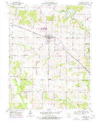
Lewistown serves as the central hub of this Missouri landscape, situated at the intersection of a established grid system and the Chicago Burlington and Quincy railroad line. The map captures a mid-century rural environment transitioning away from the small-district education model, evidenced by the multiple inactive facilities such as Turner Sch, Oakland Sch, and Glaves Sch. These former school sites are scattered throughout the townships of La Belle, Dickerson, Salem, and Highland.
Find a feature on this map
17 named features on this map. Tap any name to fly to it.
Don’t see what you’re looking for? This feature index may not catch every label — zoom into the map to look around manually.
Map Details
Editions of this 1950 Lewistown Map
2 editions found
Other maps of this area

1903 · Kahoka
USGS Topo · 1:125,000

1903 · Palmyra
USGS Topo · 1:125,000

1948 · Quincy
USGS Topo · 1:250,000

1949 · Durham
USGS Topo · 1:24,000

1950 · Durham
USGS Topo · 1:24,000

1950 · Benjamin
USGS Topo · 1:24,000

1950 · Williamstown
USGS Topo · 1:24,000
1950 · Monticello
USGS Topo · 1:24,000

1950 · La Belle
USGS Topo · 1:24,000
1951 · Benjamin
USGS Topo · 1:24,000