1930s Maps of Lanes Prairie, Missouri
Explore 2 historic maps of Lanes Prairie from the 1930s. These maps offer a rare glimpse into what life looked like during the 1930s — showing old roads, neighborhoods, homes, and landmarks that have changed or disappeared over time.
Whether you're researching your family's past, planning a metal detecting trip, or studying how Lanes Prairie's landscape evolved across the 1930s, these high-resolution maps are a powerful tool for exploring the history of this region.
- Focus on a specific era: All maps on this page are from the 1930s, giving you a focused view of this time period.
- See what’s changed: Compare century-old streets, trails, and buildings to today's modern landscape using overlays and satellite layers.
- Research with precision: Use these maps for genealogy, historical research, land use analysis, or educational projects.
- View, download, or print: Maps are fully viewable online in high resolution, and can be downloaded or printed for your own records.
Start exploring Lanes Prairie's history through authentic maps from the 1930s. This is your window into the past.
Lanes Prairie, MO maps
(2)- 1934 Map of Redbird, 1962 Print
 1934 Redbird1962 Print · USGSThe rural landscapes of Phelps, Maries, and Gasconade Counties are captured here in the 1930s, before modern highway expansion altered the backroads. Genealogists can trace family landmarks like Rock Spring Cem, Stockton Mine, and the Soldiers Home.
 - 1938 Map of Redbird
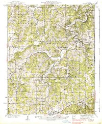 1938 Redbird1938 Print · USGSThe Missouri Ozarks during the late 1930s reveal a landscape of river-carved ridges and small agricultural hubs like St James and Highgate. Genealogists and historians can locate dozens of country landmarks, from Stockton Mines to rural schools like Lanes Prairie and the Southard Cem.3 unique versions available
End of results
Showing maps 1-2 of 2
Top cities near Lanes Prairie
- Rolla historical maps
- St. James historical maps
- Owensville historical maps
- Vienna historical maps
- Freeburg historical maps
Frequently asked questions
- What are the different types of historical maps available for Lanes Prairie?
- What is the oldest map of Lanes Prairie?
- Where can I purchase historical maps of Lanes Prairie for my home or office?
- Where can I download high-res historical maps of Lanes Prairie?
- Are there historical topographic maps available for Lanes Prairie?
- Is there historical aerial imagery available for Lanes Prairie?
- Where are historical maps of Lanes Prairie sourced from?