1940s Maps of Ozark Junction, Missouri
Explore 2 historic maps of Ozark Junction from the 1940s. These maps offer a rare glimpse into what life looked like during the 1940s — showing old roads, neighborhoods, homes, and landmarks that have changed or disappeared over time.
Whether you're researching your family's past, planning a metal detecting trip, or studying how Ozark Junction's landscape evolved across the 1940s, these high-resolution maps are a powerful tool for exploring the history of this region.
- Focus on a specific era: All maps on this page are from the 1940s, giving you a focused view of this time period.
- See what’s changed: Compare century-old streets, trails, and buildings to today's modern landscape using overlays and satellite layers.
- Research with precision: Use these maps for genealogy, historical research, land use analysis, or educational projects.
- View, download, or print: Maps are fully viewable online in high resolution, and can be downloaded or printed for your own records.
Start exploring Ozark Junction's history through authentic maps from the 1940s. This is your window into the past.
Ozark Junction, MO maps
(2)- 1947 Map of Jefferson City, 1949 Print
 1947 Jefferson City1949 Print · USGSCentral Missouri and the northern Ozarks come into focus in this late 1940s survey of the river-and-rail landscape. Genealogists and historians can trace the growth of Jefferson City and Sedalia or locate family roots near Bagnell Dam and the Lake of the Ozarks.
 - 1948 Map of Tavern, 1973 Print
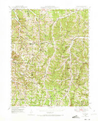 1948 Tavern1973 Print · USGSMaries County life in the late 1940s was centered on the river valleys and a network of rural schools. Genealogists can trace family landmarks like Old Van Cleve, the Barnhart Cem, and numerous schoolhouses including Camp Ground Sch.2 unique versions available
End of results
Showing maps 1-2 of 2
Top cities near Ozark Junction
- Dixon historical maps
- Crocker historical maps
- Iberia historical maps
- Doolittle historical maps
- Vienna historical maps
- Freeburg historical maps
See more
Frequently asked questions
- What are the different types of historical maps available for Ozark Junction?
- What is the oldest map of Ozark Junction?
- Where can I purchase historical maps of Ozark Junction for my home or office?
- Where can I download high-res historical maps of Ozark Junction?
- Are there historical topographic maps available for Ozark Junction?
- Is there historical aerial imagery available for Ozark Junction?
- Where are historical maps of Ozark Junction sourced from?