1900s (20th Century) Maps of Philadelphia, Missouri
Explore 6 historic maps of Philadelphia from the 1900s (20th Century). These maps offer a rare glimpse into what life looked like during the 1900s — showing old roads, neighborhoods, homes, and landmarks that have changed or disappeared over time.
Whether you're researching your family's past, planning a metal detecting trip, or studying how Philadelphia's landscape evolved across the 1900s, these high-resolution maps are a powerful tool for exploring the history of this region.
- Focus on a specific era: All maps on this page are from the 1900s, giving you a focused view of this time period.
- See what’s changed: Compare century-old streets, trails, and buildings to today's modern landscape using overlays and satellite layers.
- Research with precision: Use these maps for genealogy, historical research, land use analysis, or educational projects.
- View, download, or print: Maps are fully viewable online in high resolution, and can be downloaded or printed for your own records.
Start exploring Philadelphia's history through authentic maps from the 1900s. This is your window into the past.
Philadelphia, MO maps
(6)- 1903 Map of Palmyra
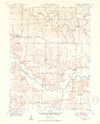
 1903 Palmyra1903 Print · USGSNortheast Missouri at the start of the twentieth century was a landscape of river-valley farming and critical rail junctions. Researchers can trace early rural life through features like Sharp Mills, St. Pauls Ch., and the crossing of the Hannibal and St. Joseph R. R.2 unique versions available
 - 1948 Map of Quincy
 1948 Quincy1948 Print · USGSThe Mississippi and Illinois River valleys are captured at a post-war crossroads as rail and river travel met the expanding highway system. Genealogists can trace family settlements from Quincy to Hannibal and smaller towns like Vandalia and Jerseyville.2 unique versions available
 - 1949 Map of Philadelphia, 1967 Print
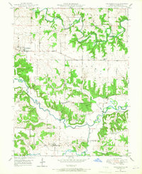 1949 Philadelphia1967 Print · USGSMarion County farming communities thrived along the river forks during the late 1940s. Genealogists can locate family landmarks and rural institutions like Pea Ridge Ch, Schmidt Sch, and the isolated Terrell Cem near the river bluffs.
 - 1950 Map of Philadelphia
 1950 Philadelphia1950 Print · USGSMarion County agriculture and education are well-documented in this mid-century survey of the Fabius River valleys. Genealogists can trace family roots through numerous rural landmarks like White Franklin Sch, Terrell Cem, and Philadelphia.2 unique versions available
 - 1956 Map of Quincy, 1967 Print
 1956 Quincy1967 Print · USGSThe river and rail corridors of the Illinois-Missouri border are documented here during the mid-1950s. Researchers can trace historic river landings and regional transit hubs from Quincy and Hannibal to smaller settlements like Meredosia and Roodhouse.3 unique versions available
 - 1986 Map of Quincy
 1986 Quincy1986 Print · USGSThe tri-state border region along the Mississippi River comes into focus during the mid-1980s. Researchers can trace the legacy of river towns and rail hubs like Quincy and Monroe City or locate landmarks such as Mount Olive Cem.2 unique versions available
End of results
Showing maps 1-6 of 6
Top cities near Philadelphia
- Palmyra historical maps
- Monroe City historical maps
- La Grange historical maps
- Ewing historical maps
- Hunnewell historical maps
- Rensselaer historical maps
Frequently asked questions
- What are the different types of historical maps available for Philadelphia?
- What is the oldest map of Philadelphia?
- Where can I purchase historical maps of Philadelphia for my home or office?
- Where can I download high-res historical maps of Philadelphia?
- Are there historical topographic maps available for Philadelphia?
- Is there historical aerial imagery available for Philadelphia?
- Where are historical maps of Philadelphia sourced from?