1980s Maps of Burrows, Missouri
Explore 2 historic maps of Burrows from the 1980s. These maps offer a rare glimpse into what life looked like during the 1980s — showing old roads, neighborhoods, homes, and landmarks that have changed or disappeared over time.
Whether you're researching your family's past, planning a metal detecting trip, or studying how Burrows's landscape evolved across the 1980s, these high-resolution maps are a powerful tool for exploring the history of this region.
- Focus on a specific era: All maps on this page are from the 1980s, giving you a focused view of this time period.
- See what’s changed: Compare century-old streets, trails, and buildings to today's modern landscape using overlays and satellite layers.
- Research with precision: Use these maps for genealogy, historical research, land use analysis, or educational projects.
- View, download, or print: Maps are fully viewable online in high resolution, and can be downloaded or printed for your own records.
Start exploring Burrows's history through authentic maps from the 1980s. This is your window into the past.
Burrows, MO maps
- 1981 Map of Akron
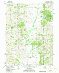 1981 Akron1981 Print · USGSThe Missouri-Iowa state line was a landscape of quiet river valleys and scattered farmsteads in the early eighties. Researchers can trace rural lineages through the many family-named burial grounds like Miller Cem or explore the Akron Townhall and the grounds of Nine Eagles State Park.
 - 1981 Map of Leon, 1982 Print
 1981 Leon1982 Print · USGSSouthern Iowa and northern Missouri are captured here in the early eighties as the rural landscape balances traditional agriculture with large-scale water management. Researchers can trace the path of the Burlington Northern through Leon or locate early settlements like Decatur City and New Buda.
End of results
Showing maps 1-2
Top cities near Burrows
- Lamoni historical maps
- Leon historical maps
- Princeton historical maps
- Ridgeway historical maps
- Cainsville historical maps
- Mercer historical maps
See more
Frequently asked questions
- What are the different types of historical maps available for Burrows?
- What is the oldest map of Burrows?
- Where can I purchase historical maps of Burrows for my home or office?
- Where can I download high-res historical maps of Burrows?
- Are there historical topographic maps available for Burrows?
- Is there historical aerial imagery available for Burrows?
- Where are historical maps of Burrows sourced from?