1970s Maps of Ogden, Missouri
Explore 2 historic maps of Ogden from the 1970s. These maps offer a rare glimpse into what life looked like during the 1970s — showing old roads, neighborhoods, homes, and landmarks that have changed or disappeared over time.
Whether you're researching your family's past, planning a metal detecting trip, or studying how Ogden's landscape evolved across the 1970s, these high-resolution maps are a powerful tool for exploring the history of this region.
- Focus on a specific era: All maps on this page are from the 1970s, giving you a focused view of this time period.
- See what’s changed: Compare century-old streets, trails, and buildings to today's modern landscape using overlays and satellite layers.
- Research with precision: Use these maps for genealogy, historical research, land use analysis, or educational projects.
- View, download, or print: Maps are fully viewable online in high resolution, and can be downloaded or printed for your own records.
Start exploring Ogden's history through authentic maps from the 1970s. This is your window into the past.
Ogden, MO maps
(2)- 1971 Map of Kewanee, 1973 Print
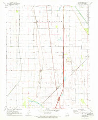 1971 Kewanee1973 Print · USGSSoutheast Missouri’s fertile lowlands are captured here in the early seventies, showcasing a landscape defined by engineered drainage and rail-side commerce. Genealogists can locate numerous small burial sites like Steele Cem and Graham Cem near the towns of Kewanee and Ristine.
 - 1973 Map of New Madrid
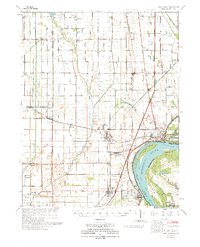 1973 New Madrid1973 Print · USGSMissouri's Bootheel region shows its deep connection to the river and rail lines during the early seventies. Genealogists and historians can trace family roots through numerous sites like Pilgrim Rest Ch, Howardville, and St Marys Cem.
End of results
Showing maps 1-2 of 2
Top cities near Ogden
- Sikeston historical maps
- Charleston historical maps
- East Prairie historical maps
- New Madrid historical maps
- Lilbourn historical maps
- Morehouse historical maps
See more
Frequently asked questions
- What are the different types of historical maps available for Ogden?
- What is the oldest map of Ogden?
- Where can I purchase historical maps of Ogden for my home or office?
- Where can I download high-res historical maps of Ogden?
- Are there historical topographic maps available for Ogden?
- Is there historical aerial imagery available for Ogden?
- Where are historical maps of Ogden sourced from?