1940s Maps of Billmore, Missouri
Explore 2 historic maps of Billmore from the 1940s. These maps offer a rare glimpse into what life looked like during the 1940s — showing old roads, neighborhoods, homes, and landmarks that have changed or disappeared over time.
Whether you're researching your family's past, planning a metal detecting trip, or studying how Billmore's landscape evolved across the 1940s, these high-resolution maps are a powerful tool for exploring the history of this region.
- Focus on a specific era: All maps on this page are from the 1940s, giving you a focused view of this time period.
- See what’s changed: Compare century-old streets, trails, and buildings to today's modern landscape using overlays and satellite layers.
- Research with precision: Use these maps for genealogy, historical research, land use analysis, or educational projects.
- View, download, or print: Maps are fully viewable online in high resolution, and can be downloaded or printed for your own records.
Start exploring Billmore's history through authentic maps from the 1940s. This is your window into the past.
Billmore, MO maps
(2)- 1941 Map of Gatewood
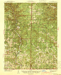 1941 Gatewood1941 Print · USGSThe Missouri Ozarks meet the Arkansas border in the 1930s, a period when the Eleven Point River was the lifeblood of remote forest communities. Researchers can locate dozens of country schoolhouses like Charter Oak Sch and river landmarks such as Stubblefield Ferry.
 - 1945 Map of Gatewood
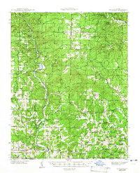 1945 Gatewood1945 Print · USGSRipley and Oregon counties are shown during the 1930s and 40s, a period defined by the growth of the national forest and river-based commerce. Genealogists can locate family landmarks like Stubblefield Ferry, Thomasons Mill, and schools such as Mt Carmel Sch.3 unique versions available
End of results
Showing maps 1-2 of 2
Top cities near Billmore
Frequently asked questions
- What are the different types of historical maps available for Billmore?
- What is the oldest map of Billmore?
- Where can I purchase historical maps of Billmore for my home or office?
- Where can I download high-res historical maps of Billmore?
- Are there historical topographic maps available for Billmore?
- Is there historical aerial imagery available for Billmore?
- Where are historical maps of Billmore sourced from?