1900s (20th Century) Maps of Potts, Missouri
Explore 9 historic maps of Potts from the 1900s (20th Century). These maps offer a rare glimpse into what life looked like during the 1900s — showing old roads, neighborhoods, homes, and landmarks that have changed or disappeared over time.
Whether you're researching your family's past, planning a metal detecting trip, or studying how Potts's landscape evolved across the 1900s, these high-resolution maps are a powerful tool for exploring the history of this region.
- Focus on a specific era: All maps on this page are from the 1900s, giving you a focused view of this time period.
- See what’s changed: Compare century-old streets, trails, and buildings to today's modern landscape using overlays and satellite layers.
- Research with precision: Use these maps for genealogy, historical research, land use analysis, or educational projects.
- View, download, or print: Maps are fully viewable online in high resolution, and can be downloaded or printed for your own records.
Start exploring Potts's history through authentic maps from the 1900s. This is your window into the past.
Potts, MO maps
(9)- 1934 Map of Linn
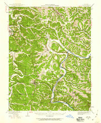
 1934 Linn1934 Print · USGSThe Osage County hills and river valleys are shown in detail during the 1930s, featuring the early networks of rural schools and family cemeteries. Genealogists can trace family names and locations at Van Buren Cem, Mt Calvary Ch, and Rich Fountain.
 - 1942 Map of Linn, 1959 Print
 1942 Linn1959 Print · USGSOsage County in the 1940s is defined by its rugged river valleys and the steady pulse of the Rock Island line. Genealogists can trace family footprints at Van Buren Cem or identify old rural school sites like Winkelman Sch and Indian Creek Sch.2 unique versions available
 - 1945 Map of Linn
 1945 Linn1945 Print · USGSOsage County in the mid-1940s was a landscape of river-valley settlements and rural schools connected by the Rock Island line. Researchers can trace ancestral locations near Westphalia and Freeburg, or locate historical river crossings like Daggetts Ford and Hoops Ford.2 unique versions available
 - 1949 Map of Saint Louis
 1949 Saint Louis1949 Print · USGSGreater St. Louis and its surrounding river valleys are captured here just after the war, showing the metropolitan core and the rural Ozark fringe. Researchers can trace the sprawling rail network of the Wabash RR or locate landmarks like Meramec Caverns Airport and Scott Air Force Base.2 unique versions available
 - 1962 Map of St. Louis
 1962 St. Louis1962 Print · USGSThe mid-century gateway to the west shows the metropolitan expansion of St Louis alongside its critical river confluences. Genealogists and historians can trace the rail corridors of the Missouri Pacific RR and settlements from Fulton to De Soto.
 - 1963 Map of St. Louis, 1970 Print
 1963 St. Louis1970 Print · USGSSt. Louis and its surrounding river valleys are captured here during the peak of mid-century suburban expansion and industrial activity. Trace the historic rail routes of the Norfolk and Western Ry or locate the St Louis Ordnance Plant and early stretches of US Highway 66.4 unique versions available
 - 1966 Map of St. Louis
 1966 St. Louis1966 Print · USGSThe St. Louis metropolitan area and its surrounding river valleys are captured here during the mid-sixties era of suburban growth and industrial strength. Genealogists and historians can trace the foundations of local communities through sites like Old Pioneer Cem, Parks College, and the Jefferson Barracks Military Reservation.
 - 1981 Map of Linn
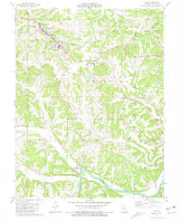 1981 Linn1981 Print · USGSIn the early 1980s, the area around Linn was a blend of academic growth and deep rural history. You can trace family lineages at the Wash Branson Cem, explore the riverfront at Rollins Ferry Public Access Area, or locate the old community of Potts.
 - 1985 Map of Sullivan
 1985 Sullivan1985 Print · USGSMid-1980s Missouri comes into focus here as the Ozark landscape balances industrial mining with river recreation. Genealogists and historians can trace the St Louis-San Francisco RR through Sullivan and locate landmarks like Pea Ridge Mine or St Cloud Church.3 unique versions available
End of results
Showing maps 1-9 of 9
Top cities near Potts
- Linn historical maps
- Chamois historical maps
- Freeburg historical maps
- Westphalia historical maps
- Gasconade historical maps
- Mokane historical maps
See more
Frequently asked questions
- What are the different types of historical maps available for Potts?
- What is the oldest map of Potts?
- Where can I purchase historical maps of Potts for my home or office?
- Where can I download high-res historical maps of Potts?
- Are there historical topographic maps available for Potts?
- Is there historical aerial imagery available for Potts?
- Where are historical maps of Potts sourced from?