1980s Maps of St. James, Missouri
Explore 6 historic maps of St. James from the 1980s. These maps offer a rare glimpse into what life looked like during the 1980s — showing old roads, neighborhoods, homes, and landmarks that have changed or disappeared over time.
Whether you're researching your family's past, planning a metal detecting trip, or studying how St. James's landscape evolved across the 1980s, these high-resolution maps are a powerful tool for exploring the history of this region.
- Focus on a specific era: All maps on this page are from the 1980s, giving you a focused view of this time period.
- See what’s changed: Compare century-old streets, trails, and buildings to today's modern landscape using overlays and satellite layers.
- Research with precision: Use these maps for genealogy, historical research, land use analysis, or educational projects.
- View, download, or print: Maps are fully viewable online in high resolution, and can be downloaded or printed for your own records.
Start exploring St. James's history through authentic maps from the 1980s. This is your window into the past.
St. James, MO maps
(6)- 1980 Map of Maramec Spring, 1981 Print
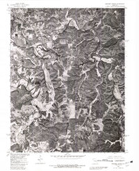 1980 Maramec Spring1981 Print · USGSThe Missouri Ozarks are captured in the early 1980s through this aerial orthophotoquad of the Phelps County countryside. Trace the rural landscape from the outskirts of St James down to the winding banks of Dry Fork and Maramec Spring.
 - 1980 Map of Dillon, 1981 Print
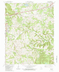
 1980 Dillon1981 Print · USGSPhelps County in the early eighties is seen through detailed aerial imagery as the corridor between Rolla and St James continues to develop. Trace the rural landscape along the Bourbeuse R and locate features like Dillon and Little Prairie Lake.
 - 1985 Map of Dillon
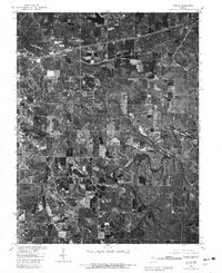
 1985 Dillon1985 Print · USGSMid-1980s Phelps County reveals the growth of ROLLA and St James along the BURLINGTON NORTHERN rail line. Genealogists can locate family landmarks like Burton Cem, Smith-Laney Cem, and Flat Grove Cem among the Ozark ridges.
 - 1985 Map of Sullivan
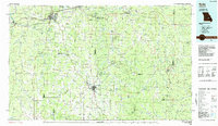
 1985 Sullivan1985 Print · USGSMid-1980s Missouri comes into focus here as the Ozark landscape balances industrial mining with river recreation. Genealogists and historians can trace the St Louis-San Francisco RR through Sullivan and locate landmarks like Pea Ridge Mine or St Cloud Church.3 unique versions available
 - 1986 Map of Rolla
 1986 Rolla1986 Print · USGSThe Missouri Ozarks are captured here in the mid-1980s, showcasing the intersection of deep forest wilderness and growing highway corridors. Genealogists and local historians can trace family roots through rural landmarks like Salem Memorial Cemetery or the rail-stop history of Cook Station and Steelville.2 unique versions available
 - 1989 Map of Rolla
 1989 Rolla1989 Print · USGSThe Missouri Ozarks are captured in the late eighties as a landscape of national forests and historic mining towns. Researchers can trace the rail lines of the Missouri Pacific RR or locate landmarks like Taum Sauk Mtn and Elephant Rocks State Park.
End of results
Showing maps 1-6 of 6
Top cities near St. James
Frequently asked questions
- What are the different types of historical maps available for St. James?
- What is the oldest map of St. James?
- Where can I purchase historical maps of St. James for my home or office?
- Where can I download high-res historical maps of St. James?
- Are there historical topographic maps available for St. James?
- Is there historical aerial imagery available for St. James?
- Where are historical maps of St. James sourced from?