1990s Maps of Clarksville, Missouri
Explore 2 historic maps of Clarksville from the 1990s. These maps offer a rare glimpse into what life looked like during the 1990s — showing old roads, neighborhoods, homes, and landmarks that have changed or disappeared over time.
Whether you're researching your family's past, planning a metal detecting trip, or studying how Clarksville's landscape evolved across the 1990s, these high-resolution maps are a powerful tool for exploring the history of this region.
- Focus on a specific era: All maps on this page are from the 1990s, giving you a focused view of this time period.
- See what’s changed: Compare century-old streets, trails, and buildings to today's modern landscape using overlays and satellite layers.
- Research with precision: Use these maps for genealogy, historical research, land use analysis, or educational projects.
- View, download, or print: Maps are fully viewable online in high resolution, and can be downloaded or printed for your own records.
Start exploring Clarksville's history through authentic maps from the 1990s. This is your window into the past.
Clarksville, MO maps
(2)- 1993 Map of Pleasant Hill West, 1996 Print
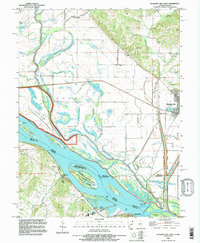 1993 Pleasant Hill West1996 Print · USGSThe Illinois-Missouri borderlands appear in the mid-1990s as a highly engineered landscape of river islands, sloughs, and levees. Researchers can trace family history at Martinsburg Cem or study river navigation at Lock and Dam No 24 and The Sny.
 - 1993 Map of Clarksville, 1996 Print
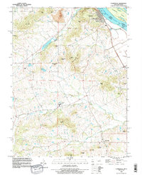 1993 Clarksville1996 Print · USGSThe Mississippi River bluffs in the 1990s show a mix of river engineering and rugged upland settlements. Researchers can locate family landmarks like Ben Watts Knob, the rural community of Paynesville, and river features such as Lock and Dam No 24.
End of results
Showing maps 1-2 of 2
Top cities near Clarksville
- Pittsfield historical maps
- Louisiana historical maps
- Elsberry historical maps
- Pleasant Hill historical maps
- Atlas historical maps
- Eolia historical maps
See more
Frequently asked questions
- What are the different types of historical maps available for Clarksville?
- What is the oldest map of Clarksville?
- Where can I purchase historical maps of Clarksville for my home or office?
- Where can I download high-res historical maps of Clarksville?
- Are there historical topographic maps available for Clarksville?
- Is there historical aerial imagery available for Clarksville?
- Where are historical maps of Clarksville sourced from?