1900s (20th Century) Maps of Clarksville, Missouri
Explore 10 historic maps of Clarksville from the 1900s (20th Century). These maps offer a rare glimpse into what life looked like during the 1900s — showing old roads, neighborhoods, homes, and landmarks that have changed or disappeared over time.
Whether you're researching your family's past, planning a metal detecting trip, or studying how Clarksville's landscape evolved across the 1900s, these high-resolution maps are a powerful tool for exploring the history of this region.
- Focus on a specific era: All maps on this page are from the 1900s, giving you a focused view of this time period.
- See what’s changed: Compare century-old streets, trails, and buildings to today's modern landscape using overlays and satellite layers.
- Research with precision: Use these maps for genealogy, historical research, land use analysis, or educational projects.
- View, download, or print: Maps are fully viewable online in high resolution, and can be downloaded or printed for your own records.
Start exploring Clarksville's history through authentic maps from the 1900s. This is your window into the past.
Clarksville, MO maps
(10)- 1930 Map of Nebo
 1930 Nebo1930 Print · USGSThe Mississippi River bottomlands and Pike County bluffs are shown here in the late twenties, featuring a landscape of sloughs and rail-dependent towns. Trace family roots at Wildcat Cem or locate rural landmarks like Riprap Landing and Old Baptist Sch.
 - 1934 Map of Nebo
 1934 Nebo1934 Print · USGSThe Mississippi River borderlands in the mid-1930s reveal a landscape of river-and-rail commerce and high-ground settlements. Researchers can trace family history through the locations of Corinth Cem, the Greenwing Club, and rural schoolhouses like Farris Sch.4 unique versions available
 - 1942 Map of Nebo
 1942 Nebo1942 Print · USGSThe Mississippi River floodplain and the rising knobs of Missouri appear here as they were in the early 1940s. Genealogists can trace a dense network of rural landmarks, from Salem Sch and Corinth Ch to the riverfront at Clarksville and Annada.2 unique versions available
 - 1948 Map of Quincy
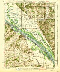
 1948 Quincy1948 Print · USGSThe Mississippi and Illinois River valleys are captured at a post-war crossroads as rail and river travel met the expanding highway system. Genealogists can trace family settlements from Quincy to Hannibal and smaller towns like Vandalia and Jerseyville.2 unique versions available
 - 1956 Map of Quincy, 1967 Print
 1956 Quincy1967 Print · USGSThe river and rail corridors of the Illinois-Missouri border are documented here during the mid-1950s. Researchers can trace historic river landings and regional transit hubs from Quincy and Hannibal to smaller settlements like Meredosia and Roodhouse.3 unique versions available
 - 1978 Map of Clarksville
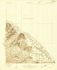
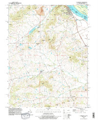
 1978 Clarksville1978 Print · USGSThe Mississippi River bluffs in Pike County are shown here in the late seventies as the river-and-rail economy shaped the landscape. Researchers can trace local history through features like Lock and Dam No 24, Clopton Sch, and family-named landmarks like Ben Watts Knob.2 unique versions available
 - 1978 Map of Pleasant Hill West
 1978 Pleasant Hill West1978 Print · USGSIn the mid-1970s, the Mississippi River bottomlands were a complex mix of wildlife refuges and rail-driven settlements. You can trace family roots at Wells Cem or explore the river infrastructure near Pleasant Hill and Atlas.2 unique versions available
 - 1985 Map of Jerseyville
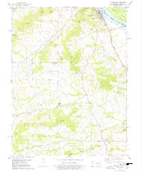
 1985 Jerseyville1985 Print · USGSThe confluence of the Illinois and Mississippi rivers defines this 1980s landscape of fertile bottomlands and rail-hub towns. Genealogists and historians can trace the foundations of communities like Jerseyville and White Hall alongside the Oak Grove Cem and St Mary Church.2 unique versions available
 - 1993 Map of Pleasant Hill West, 1996 Print
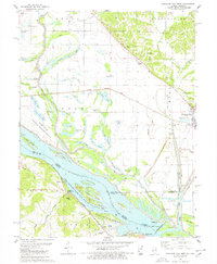
 1993 Pleasant Hill West1996 Print · USGSThe Illinois-Missouri borderlands appear in the mid-1990s as a highly engineered landscape of river islands, sloughs, and levees. Researchers can trace family history at Martinsburg Cem or study river navigation at Lock and Dam No 24 and The Sny.
 - 1993 Map of Clarksville, 1996 Print
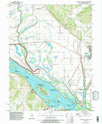
 1993 Clarksville1996 Print · USGSThe Mississippi River bluffs in the 1990s show a mix of river engineering and rugged upland settlements. Researchers can locate family landmarks like Ben Watts Knob, the rural community of Paynesville, and river features such as Lock and Dam No 24.
End of results
Showing maps 1-10 of 10
Top cities near Clarksville
- Pittsfield historical maps
- Louisiana historical maps
- Elsberry historical maps
- Pleasant Hill historical maps
- Atlas historical maps
- Eolia historical maps
See more
Frequently asked questions
- What are the different types of historical maps available for Clarksville?
- What is the oldest map of Clarksville?
- Where can I purchase historical maps of Clarksville for my home or office?
- Where can I download high-res historical maps of Clarksville?
- Are there historical topographic maps available for Clarksville?
- Is there historical aerial imagery available for Clarksville?
- Where are historical maps of Clarksville sourced from?