
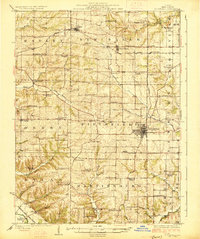
1930 Map of Nebo
USGS Topo · Published 1930About this map
Pleasant Hill and the surrounding river bottomlands of Pike Co are defined by an intricate network of sloughs and cutoffs that trace the ancient movements of the Mississippi River. This 1920s-era landscape, captured by surveyors F.W. Hughes and J.A. Duck, reveals a highly localized rural infrastructure of small schools like Franklin Sch and Stockland Sch serving isolated farming communities. The Alton Railroad provides a vital east-west link through the hills, while the Chicago and Alton Railroad skirts the riverbank near Quincy Junction.
Find a feature on this map
81 named features on this map. Tap any name to fly to it.
Don’t see what you’re looking for? This feature index may not catch every label — zoom into the map to look around manually.
Map Details
Editions of this 1930 Nebo Map
This is the sole edition of this map. No revisions or reprints were ever made.
Other maps of this area

1890 · Louisiana
USGS Topo · 1:125,000

1924 · Griggsville
USGS Topo · 1:62,500

1926 · Griggsville
USGS Topo · 1:62,500
1926 · Pittsfield
USGS Topo · 1:62,500

1930 · Pearl
USGS Topo · 1:62,500

1930 · Hardin
USGS Topo · 1:62,500

1931 · Barry
USGS Topo · 1:62,500
1934 · Nebo
USGS Topo · 1:48,000
1934 · Elsberry
USGS Topo · 1:48,000

1934 · Hardin
USGS Topo · 1:62,500