
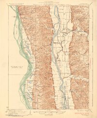
1930 Map of Hardin
USGS Topo · Published 1930About this map
Hardin sits at the narrowest point between the Mississippi River and the Illinois River, anchoring a landscape defined by river navigation and rural education in the late 1920s. This survey, compiled in part from early Air Corps aerial photography, reveals a dense network of country schools such as Pecan Grove Sch and Teneriffe Sch serving isolated hollows like De Gerlia Hollow and Poor Farm Hollow. The importance of the water is evident in the numerous landings along the banks, including Burr Oak Ldg and Gilead Ldg, which once served as vital commerce points for local farm produce.
Find a feature on this map
148 named features on this map. Tap any name to fly to it.
Don’t see what you’re looking for? This feature index may not catch every label — zoom into the map to look around manually.
Map Details
Editions of this 1930 Hardin Map
2 editions found
Other maps of this area

1903 · O'Fallon
USGS Topo · 1:125,000

1924 · Roodhouse
USGS Topo · 1:62,500

1926 · Roodhouse
USGS Topo · 1:62,500

1927 · St. Charles
USGS Topo · 1:62,500

1930 · Pearl
USGS Topo · 1:62,500

1930 · Nebo
USGS Topo · 1:62,500

1930 · Jerseyville
USGS Topo · 1:62,500

1931 · Brussels
USGS Topo · 1:62,500

1933 · Jerseyville
USGS Topo · 1:62,500

1933 · Saint Charles
USGS Topo · 1:62,500