
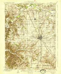
1933 Map of Jerseyville
USGS Topo · Published 1933About this map
Jerseyville serves as the focal point of this Jersey County landscape, shown here at a time when a dense network of country schools and small settlements defined rural Illinois life. The map illustrates the convergence of the Chicago and Alton RR and the Chicago Springfield and St Louis RR, which helped drive the region's agricultural economy. Beyond the main town, the land is dotted with localized landmarks of genealogical interest, including the Hickory Log Sch, Shakerag Sch, and St Marys Sch. To the north, the transition between Old Kane and Kane is clearly visible, while the southern reaches follow the drainages of Otter Creek toward Otterville. Notable natural features like Democrat Spring and Shanks Hill provide further points of orientation for researchers tracing family lands or local history in this pre-war era.
Find a feature on this map
82 named features on this map. Tap any name to fly to it.
Don’t see what you’re looking for? This feature index may not catch every label — zoom into the map to look around manually.
Map Details
Editions of this 1933 Jerseyville Map
2 editions found
Other maps of this area

1903 · O'Fallon
USGS Topo · 1:125,000

1924 · Roodhouse
USGS Topo · 1:62,500

1925 · Brighton
USGS Topo · 1:62,500

1926 · Roodhouse
USGS Topo · 1:62,500

1927 · Alton
USGS Topo · 1:62,500

1927 · St. Charles
USGS Topo · 1:62,500

1928 · Brighton
USGS Topo · 1:62,500

1930 · Pearl
USGS Topo · 1:62,500

1930 · Hardin
USGS Topo · 1:62,500

1930 · Jerseyville
USGS Topo · 1:62,500