
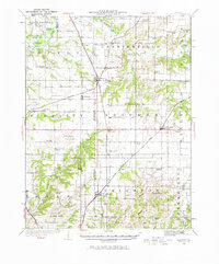
1925 Map of Brighton
USGS Topo · Published 1958About this map
Brighton and Shipman serve as primary hubs in this agricultural and transit landscape spanning the Jersey and Macoupin County border. The map illustrates a dense network of country schools that once anchored these rural communities, including Brush College School, Locust Grove School, and Diamond Hill School. These small school districts, often spaced just a few miles apart, reflect the decentralized education system of the early twentieth century before modern consolidation.
Find a feature on this map
55 named features on this map. Tap any name to fly to it.
Don’t see what you’re looking for? This feature index may not catch every label — zoom into the map to look around manually.
Map Details
Editions of this 1925 Brighton Map
2 editions found
Other maps of this area

1912 · Gillespie
USGS Topo · 1:62,500

1915 · Gillespie
USGS Topo · 1:62,500

1923 · Carlinville
USGS Topo · 1:48,000

1924 · Roodhouse
USGS Topo · 1:62,500

1925 · Carlinville
USGS Topo · 1:62,500

1926 · Roodhouse
USGS Topo · 1:62,500

1927 · Alton
USGS Topo · 1:62,500

1927 · St. Charles
USGS Topo · 1:62,500

1927 · Edwardsville
USGS Topo · 1:62,500

1928 · Brighton
USGS Topo · 1:62,500