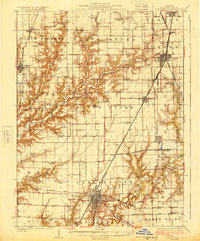
1923 Map of Carlinville
USGS Topo · Published 1923About this map
Carlinville serves as the hub of this 1923 central Illinois landscape, where an extensive network of early railroads and country schools defines the rural character of Macoupin County. The map documents a transition in transportation, showing the Illinois Traction System electric line running parallel to steam roads like the Chicago and Alton. This era represents a peak for local institutional life, evidenced by a high density of rural schoolhouses such as Sugar Creek School, Pleasant Hill School, and East Union School located every few miles to serve farming families.
Find a feature on this map
81 named features on this map. Tap any name to fly to it.
Don’t see what you’re looking for? This feature index may not catch every label — zoom into the map to look around manually.
Map Details
Editions of this 1923 Carlinville Map
This is the sole edition of this map. No revisions or reprints were ever made.
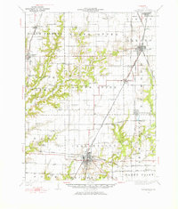
Historical Maps of Carlinville Through Time
3 maps found