
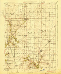
1925 Map of Raymond
USGS Topo · Published 1925About this map
Raymond and Harvel serve as the primary hubs for this section of Montgomery County, where the agricultural landscape is organized around a dense grid of rural schools and country churches. The map documents a period when the local economy relied heavily on rail corridors, with the Illinois Central and Wabash lines facilitating the transport of grain and livestock from settlements like Farmersville and Waggoner. An interesting historical detail is the abandoned segment of the Chicago and Alton railroad passing near Barnett, indicating early shifts in the region's transport network. The landscape is deeply carved by drainage systems including Macoupin Creek and Horse Creek, which dictated the placement of pioneer landmarks such as Providence Church and New Hope Church. Dozens of named schools, from Lone Elm School to Star Union School, reflect the high density of rural families in the 1920s.
Find a feature on this map
77 named features on this map. Tap any name to fly to it.
Don’t see what you’re looking for? This feature index may not catch every label — zoom into the map to look around manually.
Map Details
Editions of this 1925 Raymond Map
2 editions found
Other maps of this area

1912 · Gillespie
USGS Topo · 1:62,500

1915 · Gillespie
USGS Topo · 1:62,500

1915 · Mount Olive
USGS Topo · 1:62,500

1922 · Divernon
USGS Topo · 1:62,500

1923 · Carlinville
USGS Topo · 1:48,000

1923 · Taylorville
USGS Topo · 1:62,500

1923 · Raymond
USGS Topo · 1:62,500

1924 · Divernon
USGS Topo · 1:62,500

1924 · Waverly
USGS Topo · 1:62,500

1925 · Taylorville
USGS Topo · 1:62,500