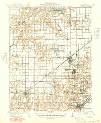
1912 Map of Gillespie
USGS Topo · Published 1971About this map
Gillespie and its neighboring coal towns emerge as major industrial hubs during the height of the early 20th-century Illinois mining boom. This landscape is defined by its intensive extraction economy, evidenced by the numerous specialized facilities like the Coal Washer near Cahokia and numbered operations such as Mine No 1 and Mine No 15. The transit network is exceptionally dense, showing the competing lines of the Illinois Traction, the Wabash, and the Chicago and Northwestern as they move fuel and passengers between Staunton and Benld. Away from the rail corridors, the rural character persists through a remarkably high density of family and community landmarks. One can trace the social fabric of Macoupin County through the dozens of named country schoolhouses, such as Spanish Needle School, Hickory Grove School, and Burton School, alongside rural meeting places like East Liberty Church.
Find a feature on this map
90 named features on this map. Tap any name to fly to it.
Don’t see what you’re looking for? This feature index may not catch every label — zoom into the map to look around manually.
Map Details
Editions of this 1912 Gillespie Map
This is the sole edition of this map. No revisions or reprints were ever made.