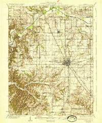
1933 Map of Jerseyville
USGS Topo · Published 1933About this map
Jerseyville stands as the central hub of this Depression-era survey, where the intersecting lines of the Chicago and Alton Railroad and the Chicago Springfield and St Louis Railroad define the local economy. The landscape is dense with rural education and civic markers, from the County Farm just outside the main settlement to a high concentration of country schools such as Hickory Log Sch and Green Persimmon Sch. These small schoolhouses, spaced across townships like English and Kane, reflect a highly localized social structure before the mid-century trend of district consolidation.
Find a feature on this map
65 named features on this map. Tap any name to fly to it.
Don’t see what you’re looking for? This feature index may not catch every label — zoom into the map to look around manually.
Map Details
Editions of this 1933 Jerseyville Map
2 editions found

Other maps of this area

1903 · O'Fallon
USGS Topo · 1:125,000

1924 · Roodhouse
USGS Topo · 1:62,500

1925 · Brighton
USGS Topo · 1:62,500

1926 · Roodhouse
USGS Topo · 1:62,500

1927 · Alton
USGS Topo · 1:62,500

1927 · St. Charles
USGS Topo · 1:62,500

1928 · Brighton
USGS Topo · 1:62,500

1930 · Pearl
USGS Topo · 1:62,500

1930 · Hardin
USGS Topo · 1:62,500

1930 · Jerseyville
USGS Topo · 1:62,500