
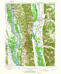
1934 Map of Hardin
USGS Topo · Published 1956About this map
The confluence of the Mississippi River and the Illinois River dominates this mid-1930s landscape, where river commerce and local agriculture meet. Small settlements like Hardin, Hamburg, and Batchtown are connected by a network of landings and sloughs, reflecting an era before modern bridges fully replaced the river's role as the primary artery for movement. The topography transitions from the broad, island-filled alluvial plains of the Mississippi to the steep bluffs of Calhoun County, punctuated by numerous hollows such as Irish Hollow and Michael Hollow. Genealogists will find a high density of rural institutions, from the Indian Creek Ch to the Forest Oak Sch and the Witachek Mound. The presence of the Chicago and Alton RR on the Illinois side and various landings like Old Westport Landing and Sterling Landing underscores the region's historical dependence on both rail and water transport.
Find a feature on this map
159 named features on this map. Tap any name to fly to it.
Don’t see what you’re looking for? This feature index may not catch every label — zoom into the map to look around manually.
Map Details
Editions of this 1934 Hardin Map
2 editions found
Other maps of this area

1903 · O'Fallon
USGS Topo · 1:125,000
1924 · Roodhouse
USGS Topo · 1:62,500
1926 · Roodhouse
USGS Topo · 1:62,500

1927 · St. Charles
USGS Topo · 1:62,500

1930 · Pearl
USGS Topo · 1:62,500

1930 · Nebo
USGS Topo · 1:62,500

1930 · Hardin
USGS Topo · 1:62,500

1930 · Jerseyville
USGS Topo · 1:62,500

1931 · Brussels
USGS Topo · 1:62,500
1933 · Jerseyville
USGS Topo · 1:62,500