1930s Maps of Eolia, Missouri
Explore 2 historic maps of Eolia from the 1930s. These maps offer a rare glimpse into what life looked like during the 1930s — showing old roads, neighborhoods, homes, and landmarks that have changed or disappeared over time.
Whether you're researching your family's past, planning a metal detecting trip, or studying how Eolia's landscape evolved across the 1930s, these high-resolution maps are a powerful tool for exploring the history of this region.
- Focus on a specific era: All maps on this page are from the 1930s, giving you a focused view of this time period.
- See what’s changed: Compare century-old streets, trails, and buildings to today's modern landscape using overlays and satellite layers.
- Research with precision: Use these maps for genealogy, historical research, land use analysis, or educational projects.
- View, download, or print: Maps are fully viewable online in high resolution, and can be downloaded or printed for your own records.
Start exploring Eolia's history through authentic maps from the 1930s. This is your window into the past.
Eolia, MO maps
(2)- 1937 Map of Silex, 1955 Print
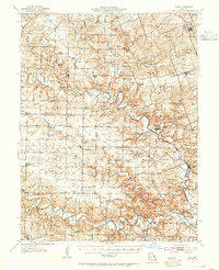 1937 Silex1955 Print · USGSLincoln and Pike counties are shown here in the mid-1930s, when the agricultural economy was centered on the banks of the Cuivre River. Genealogists and local historians can trace rural school districts and old fords, such as Abe Duff Sch, Silex, and Richardson Mill Ford.
 - 1939 Map of Silex
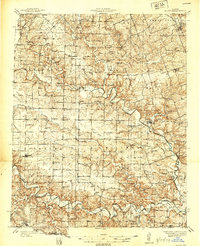 1939 Silex1939 Print · USGSLincoln and Pike Counties are shown in the late 1930s, featuring a landscape defined by the winding Cuivre River and its many forks. Researchers can trace rural life through dozens of local landmarks like Forest Cem Sch, Fairview Ch, and the St Louis and Hannibal RR.
End of results
Showing maps 1-2 of 2
Top cities near Eolia
- Bowling Green historical maps
- Louisiana historical maps
- Elsberry historical maps
- Pleasant Hill historical maps
- Clarksville historical maps
- Nebo historical maps
See more
Frequently asked questions
- What are the different types of historical maps available for Eolia?
- What is the oldest map of Eolia?
- Where can I purchase historical maps of Eolia for my home or office?
- Where can I download high-res historical maps of Eolia?
- Are there historical topographic maps available for Eolia?
- Is there historical aerial imagery available for Eolia?
- Where are historical maps of Eolia sourced from?