1940s Maps of Mazzaville Resort, Missouri
Explore 2 historic maps of Mazzaville Resort from the 1940s. These maps offer a rare glimpse into what life looked like during the 1940s — showing old roads, neighborhoods, homes, and landmarks that have changed or disappeared over time.
Whether you're researching your family's past, planning a metal detecting trip, or studying how Mazzaville Resort's landscape evolved across the 1940s, these high-resolution maps are a powerful tool for exploring the history of this region.
- Focus on a specific era: All maps on this page are from the 1940s, giving you a focused view of this time period.
- See what’s changed: Compare century-old streets, trails, and buildings to today's modern landscape using overlays and satellite layers.
- Research with precision: Use these maps for genealogy, historical research, land use analysis, or educational projects.
- View, download, or print: Maps are fully viewable online in high resolution, and can be downloaded or printed for your own records.
Start exploring Mazzaville Resort's history through authentic maps from the 1940s. This is your window into the past.
Mazzaville Resort, MO maps
(2)- 1942 Map of Waynesville
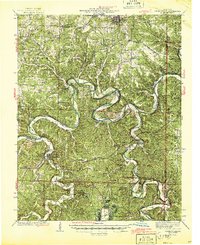 1942 Waynesville1942 Print · USGSPulaski County during the early 1940s shows a landscape of deep river bends and the emergence of wartime infrastructure. Genealogists can trace family roots through numerous sites like Burchard Cem, the Old Indian Lead Mine, and the original footprint of Fort Leonard Wood.
 - 1944 Map of Waynesville
 1944 Waynesville1944 Print · USGSPulaski County at the peak of the Second World War shows a landscape in transition as the new Fort Leonard Wood takes shape among the Ozark hills. Genealogists and researchers can trace family-named sites like Wheelers Mill, Riddle Bridge, and the Joiner Cem along the winding Gasconade River.2 unique versions available
End of results
Showing maps 1-2 of 2
Top cities near Mazzaville Resort
- Rolla historical maps
- Saint Robert historical maps
- Waynesville historical maps
- Dixon historical maps
- Crocker historical maps
- Doolittle historical maps
See more
Frequently asked questions
- What are the different types of historical maps available for Mazzaville Resort?
- What is the oldest map of Mazzaville Resort?
- Where can I purchase historical maps of Mazzaville Resort for my home or office?
- Where can I download high-res historical maps of Mazzaville Resort?
- Are there historical topographic maps available for Mazzaville Resort?
- Is there historical aerial imagery available for Mazzaville Resort?
- Where are historical maps of Mazzaville Resort sourced from?