1910s Maps of Martinstown, Missouri
Explore 2 historic maps of Martinstown from the 1910s. These maps offer a rare glimpse into what life looked like during the 1910s — showing old roads, neighborhoods, homes, and landmarks that have changed or disappeared over time.
Whether you're researching your family's past, planning a metal detecting trip, or studying how Martinstown's landscape evolved across the 1910s, these high-resolution maps are a powerful tool for exploring the history of this region.
- Focus on a specific era: All maps on this page are from the 1910s, giving you a focused view of this time period.
- See what’s changed: Compare century-old streets, trails, and buildings to today's modern landscape using overlays and satellite layers.
- Research with precision: Use these maps for genealogy, historical research, land use analysis, or educational projects.
- View, download, or print: Maps are fully viewable online in high resolution, and can be downloaded or printed for your own records.
Start exploring Martinstown's history through authentic maps from the 1910s. This is your window into the past.
Martinstown, MO maps
(2)- 1912 Map of Green City, 1968 Print
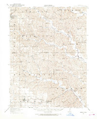 1912 Green City1968 Print · USGSNorthern Missouri at the dawn of the twentieth century reveals a landscape shaped by rural education and early rail lines. Local historians can trace dozens of country schools like Boon Hill School and vanished stops along the Quincy Omaha and Kansas City railroad.
 - 1914 Map of Green City
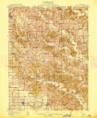 1914 Green City1914 Print · USGSNorth-central Missouri thrived as a patchwork of small townships and family farms during the early twentieth century. Genealogists can trace rural life through dozens of local landmarks like Unionville, Shibley Point School, and the Kansas City and Omaha rail line.2 unique versions available
End of results
Showing maps 1-2 of 2
Top cities near Martinstown
- Kirksville historical maps
- Unionville historical maps
- Green City historical maps
- Queen City historical maps
- Novinger historical maps
- Cincinnati historical maps
See more
Frequently asked questions
- What are the different types of historical maps available for Martinstown?
- What is the oldest map of Martinstown?
- Where can I purchase historical maps of Martinstown for my home or office?
- Where can I download high-res historical maps of Martinstown?
- Are there historical topographic maps available for Martinstown?
- Is there historical aerial imagery available for Martinstown?
- Where are historical maps of Martinstown sourced from?