1990s Maps of Saint Peters, Missouri
Explore 4 historic maps of Saint Peters from the 1990s. These maps offer a rare glimpse into what life looked like during the 1990s — showing old roads, neighborhoods, homes, and landmarks that have changed or disappeared over time.
Whether you're researching your family's past, planning a metal detecting trip, or studying how Saint Peters's landscape evolved across the 1990s, these high-resolution maps are a powerful tool for exploring the history of this region.
- Focus on a specific era: All maps on this page are from the 1990s, giving you a focused view of this time period.
- See what’s changed: Compare century-old streets, trails, and buildings to today's modern landscape using overlays and satellite layers.
- Research with precision: Use these maps for genealogy, historical research, land use analysis, or educational projects.
- View, download, or print: Maps are fully viewable online in high resolution, and can be downloaded or printed for your own records.
Start exploring Saint Peters's history through authentic maps from the 1990s. This is your window into the past.
Saint Peters, MO maps
(4)- 1994 Map of O'Fallon, 1995 Print
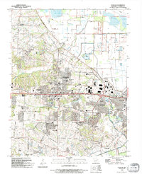 1994 O'Fallon1995 Print · USGSThe rapid expansion of O'Fallon and St. Peters is on full display in the mid-1990s as suburban growth meets established rural landmarks. Researchers can trace local history through sites like Assumption Cemetery, St Marys College, and the Waldmeister Landing Strip.
 - 1994 Map of Weldon Spring, 1995 Print
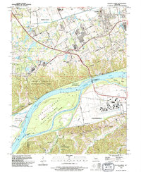 1994 Weldon Spring1995 Print · USGSThe Missouri River corridor near Chesterfield and Weldon Spring is shown here in the mid-1990s as suburban development meets extensive wildlife preserves. Researchers can trace historic family burial sites like Pitman Cem and Wolf Cem or locate regional landmarks such as Spirit of St Louis Airport and the Katy Trail State Park.
 - 1994 Map of Chesterfield, 1995 Print
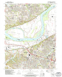 1994 Chesterfield1995 Print · USGSMid-1990s St. Louis County shows a landscape in transition as suburban development reaches the Missouri River bluffs. Researchers can trace the layout of Chesterfield, find the Gumbo Cem, or locate landmarks like Maryville University.
 - 1994 Map of Kampville, 1995 Print
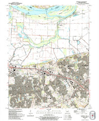 1994 Kampville1995 Print · USGSThe Missouri riverfront near St. Charles shows a landscape of agricultural levees and rapid suburban growth in the mid-1990s. Trace old river landings like McCann Landing, the route of the Katy Trail State Park, and the Golden Eagle Ferry.
End of results
Showing maps 1-4 of 4
Top cities near Saint Peters
- O'Fallon historical maps
- Saint Charles historical maps
- Florissant historical maps
- Chesterfield historical maps
- Wentzville historical maps
- Wildwood historical maps
See more
Top neighborhoods of Saint Peters
Frequently asked questions
- What are the different types of historical maps available for Saint Peters?
- What is the oldest map of Saint Peters?
- Where can I purchase historical maps of Saint Peters for my home or office?
- Where can I download high-res historical maps of Saint Peters?
- Are there historical topographic maps available for Saint Peters?
- Is there historical aerial imagery available for Saint Peters?
- Where are historical maps of Saint Peters sourced from?