1960s Maps of Cherry Box, Missouri
Explore 2 historic maps of Cherry Box from the 1960s. These maps offer a rare glimpse into what life looked like during the 1960s — showing old roads, neighborhoods, homes, and landmarks that have changed or disappeared over time.
Whether you're researching your family's past, planning a metal detecting trip, or studying how Cherry Box's landscape evolved across the 1960s, these high-resolution maps are a powerful tool for exploring the history of this region.
- Focus on a specific era: All maps on this page are from the 1960s, giving you a focused view of this time period.
- See what’s changed: Compare century-old streets, trails, and buildings to today's modern landscape using overlays and satellite layers.
- Research with precision: Use these maps for genealogy, historical research, land use analysis, or educational projects.
- View, download, or print: Maps are fully viewable online in high resolution, and can be downloaded or printed for your own records.
Start exploring Cherry Box's history through authentic maps from the 1960s. This is your window into the past.
Cherry Box, MO maps
(2)- 1960 Map of Moberly
 1960 Moberly1960 Print · USGSCentral Missouri comes alive in the mid-twentieth century as a bustling network of river towns and significant rail corridors. Genealogists and historians can trace the paths of the Wabash RR through Moberly or explore the riverfronts of Lexington and Brunswick.
 - 1963 Map of Leonard, 1965 Print
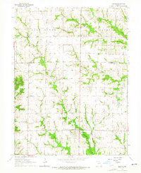 1963 Leonard1965 Print · USGSNortheast Missouri farm life is preserved here during the early sixties, showing the rural communities along the Salt River. Genealogists can locate several family burial sites like Antioch Cemetery and trace the road network around Leonard and Cherry Box.
End of results
Showing maps 1-2 of 2
Top cities near Cherry Box
- Macon historical maps
- Shelbina historical maps
- Clarence historical maps
- Shelbyville historical maps
- Brashear historical maps
- Hurdland historical maps
See more
Frequently asked questions
- What are the different types of historical maps available for Cherry Box?
- What is the oldest map of Cherry Box?
- Where can I purchase historical maps of Cherry Box for my home or office?
- Where can I download high-res historical maps of Cherry Box?
- Are there historical topographic maps available for Cherry Box?
- Is there historical aerial imagery available for Cherry Box?
- Where are historical maps of Cherry Box sourced from?