1940s Maps of Iconium, Missouri
Explore 3 historic maps of Iconium from the 1940s. These maps offer a rare glimpse into what life looked like during the 1940s — showing old roads, neighborhoods, homes, and landmarks that have changed or disappeared over time.
Whether you're researching your family's past, planning a metal detecting trip, or studying how Iconium's landscape evolved across the 1940s, these high-resolution maps are a powerful tool for exploring the history of this region.
- Focus on a specific era: All maps on this page are from the 1940s, giving you a focused view of this time period.
- See what’s changed: Compare century-old streets, trails, and buildings to today's modern landscape using overlays and satellite layers.
- Research with precision: Use these maps for genealogy, historical research, land use analysis, or educational projects.
- View, download, or print: Maps are fully viewable online in high resolution, and can be downloaded or printed for your own records.
Start exploring Iconium's history through authentic maps from the 1940s. This is your window into the past.
Iconium, MO maps
(3)- 1940 Map of Iconium, 1963 Print
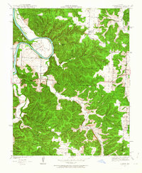 1940 Iconium1963 Print · USGSNear the bend of the Osage River just before the war, this rural landscape reveals a network of Missouri hollows and prairie lands. Genealogists can trace early homesteads and community hubs like Iconium, Liberty Sch, and the Boy Scout Camp.2 unique versions available
 - 1944 Map of Iconium
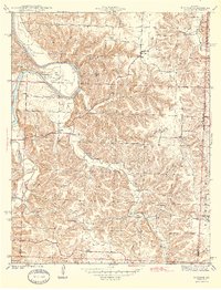 1944 Iconium1944 Print · USGSThe Osage River bends through the St. Clair County hills in the early 1940s, revealing a landscape of steep hollows and upland farms. Trace local family roots at Iconium, Corbin Ch, and several rural schoolhouses like Square Prairie Sch.2 unique versions available
 - 1947 Map of Jefferson City, 1949 Print
 1947 Jefferson City1949 Print · USGSCentral Missouri and the northern Ozarks come into focus in this late 1940s survey of the river-and-rail landscape. Genealogists and historians can trace the growth of Jefferson City and Sedalia or locate family roots near Bagnell Dam and the Lake of the Ozarks.
End of results
Showing maps 1-3 of 3
Top cities near Iconium
- Warsaw historical maps
- Osceola historical maps
- Lowry City historical maps
- Weaubleau historical maps
- Deepwater historical maps
- Hermitage historical maps
See more
Frequently asked questions
- What are the different types of historical maps available for Iconium?
- What is the oldest map of Iconium?
- Where can I purchase historical maps of Iconium for my home or office?
- Where can I download high-res historical maps of Iconium?
- Are there historical topographic maps available for Iconium?
- Is there historical aerial imagery available for Iconium?
- Where are historical maps of Iconium sourced from?