1940s Maps of Taberville, Missouri
Explore 2 historic maps of Taberville from the 1940s. These maps offer a rare glimpse into what life looked like during the 1940s — showing old roads, neighborhoods, homes, and landmarks that have changed or disappeared over time.
Whether you're researching your family's past, planning a metal detecting trip, or studying how Taberville's landscape evolved across the 1940s, these high-resolution maps are a powerful tool for exploring the history of this region.
- Focus on a specific era: All maps on this page are from the 1940s, giving you a focused view of this time period.
- See what’s changed: Compare century-old streets, trails, and buildings to today's modern landscape using overlays and satellite layers.
- Research with precision: Use these maps for genealogy, historical research, land use analysis, or educational projects.
- View, download, or print: Maps are fully viewable online in high resolution, and can be downloaded or printed for your own records.
Start exploring Taberville's history through authentic maps from the 1940s. This is your window into the past.
Taberville, MO maps
(2)- 1940 Map of Taberville
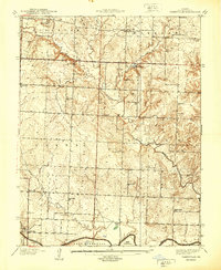 1940 Taberville1940 Print · USGSSettled along the northern banks of the Osage River just before the mid-century, this area of St. Clair County shows a landscape of small mines and rural schoolhouses. Genealogists can trace family landmarks like Ridgeway Cem or the sites of Gray's Mine and Johnson City.
 - 1947 Map of Jefferson City, 1949 Print
 1947 Jefferson City1949 Print · USGSCentral Missouri and the northern Ozarks come into focus in this late 1940s survey of the river-and-rail landscape. Genealogists and historians can trace the growth of Jefferson City and Sedalia or locate family roots near Bagnell Dam and the Lake of the Ozarks.
End of results
Showing maps 1-2 of 2
Top cities near Taberville
- El Dorado Springs historical maps
- Appleton City historical maps
- Schell City historical maps
- Pleasant Gap historical maps
- Hudson historical maps
- Rockville historical maps
See more
Frequently asked questions
- What are the different types of historical maps available for Taberville?
- What is the oldest map of Taberville?
- Where can I purchase historical maps of Taberville for my home or office?
- Where can I download high-res historical maps of Taberville?
- Are there historical topographic maps available for Taberville?
- Is there historical aerial imagery available for Taberville?
- Where are historical maps of Taberville sourced from?