1990s Maps of Marmaros, Missouri
Explore 1 historic maps of Marmaros from the 1990s. These maps offer a rare glimpse into what life looked like during the 1990s — showing old roads, neighborhoods, homes, and landmarks that have changed or disappeared over time.
Whether you're researching your family's past, planning a metal detecting trip, or studying how Marmaros's landscape evolved across the 1990s, these high-resolution maps are a powerful tool for exploring the history of this region.
- Focus on a specific era: All maps on this page are from the 1990s, giving you a focused view of this time period.
- See what’s changed: Compare century-old streets, trails, and buildings to today's modern landscape using overlays and satellite layers.
- Research with precision: Use these maps for genealogy, historical research, land use analysis, or educational projects.
- View, download, or print: Maps are fully viewable online in high resolution, and can be downloaded or printed for your own records.
Start exploring Marmaros's history through authentic maps from the 1990s. This is your window into the past.
Marmaros, MO maps
(1)- 1999 Map of Lampe, 2002 Print
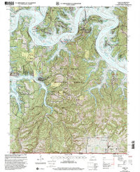 1999 Lampe2002 Print · USGSThe Missouri Ozarks meet the Arkansas border in the late nineties, showcasing a landscape reshaped by the waters of Table Rock Lake. Genealogists can trace rural landmarks like Old Elm Tree Ch, Rhodes Cem, and the upland heights of Big Joe Bald.
End of results
Showing maps 1-1 of 1
Top cities near Marmaros
- Branson historical maps
- Berryville historical maps
- Hollister historical maps
- Kimberling City historical maps
- Reeds Spring historical maps
- Galena historical maps
See more
Frequently asked questions
- What are the different types of historical maps available for Marmaros?
- What is the oldest map of Marmaros?
- Where can I purchase historical maps of Marmaros for my home or office?
- Where can I download high-res historical maps of Marmaros?
- Are there historical topographic maps available for Marmaros?
- Is there historical aerial imagery available for Marmaros?
- Where are historical maps of Marmaros sourced from?