1980s Maps of Sullivan County, Missouri
Explore 4 historic maps of Sullivan County from the 1980s. These maps offer a rare glimpse into what life looked like during the 1980s — showing old roads, neighborhoods, homes, and landmarks that have changed or disappeared over time.
Whether you're researching your family's past, planning a metal detecting trip, or studying how Sullivan County's landscape evolved across the 1980s, these high-resolution maps are a powerful tool for exploring the history of this region.
- Focus on a specific era: All maps on this page are from the 1980s, giving you a focused view of this time period.
- See what’s changed: Compare century-old streets, trails, and buildings to today's modern landscape using overlays and satellite layers.
- Research with precision: Use these maps for genealogy, historical research, land use analysis, or educational projects.
- View, download, or print: Maps are fully viewable online in high resolution, and can be downloaded or printed for your own records.
Start exploring Sullivan County's history through authentic maps from the 1980s. This is your window into the past.
Sullivan County, MO maps
(4)- 1981 Map of Trenton
 1981 Trenton1981 Print · USGSNorthern Missouri in the early eighties remains a landscape defined by its river valleys and intersecting rail lines. Genealogists and local historians can trace the development of riverside towns like Trenton and Princeton or locate smaller rural junctions such as Humphreys and Brimson.
 - 1981 Map of Kirksville, 1982 Print
 1981 Kirksville1982 Print · USGSNortheast Missouri in the early eighties was a landscape of rail-connected trade towns and significant river valleys. Researchers can trace the legacy of medical education at the Kirksville College of Osteopathic Med or locate family roots in Unionville, Edina, and Bible Grove.
 - 1984 Map of Lindley, 1985 Print
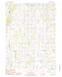 1984 Lindley1985 Print · USGSSullivan County and the surrounding tri-county borderlands are captured here in the early eighties as a network of rural townships and winding creeks. Genealogists and local researchers can trace family lands near Humphreys, Lindley, and the small settlement of Haseville.
 - 1984 Map of Osgood, 1985 Print
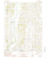 1984 Osgood1985 Print · USGSSullivan County agriculture and the watercourse of Medicine Creek define this region in the early 1980s. Genealogists can trace the rural layouts of Osgood and Humphreys or explore the boundaries of Liberty and Bowman townships.
End of results
Showing maps 1-4 of 4
Top cities of Sullivan County
- Milan historical maps
- Green City historical maps
- Newtown historical maps
- Humphreys historical maps
- Pollock historical maps
- Harris historical maps
See more
Frequently asked questions
- What are the different types of historical maps available for Sullivan County?
- What is the oldest map of Sullivan County?
- Where can I purchase historical maps of Sullivan County for my home or office?
- Where can I download high-res historical maps of Sullivan County?
- Are there historical topographic maps available for Sullivan County?
- Is there historical aerial imagery available for Sullivan County?
- Where are historical maps of Sullivan County sourced from?