1930s Maps of Sullivan, Missouri
Explore 2 historic maps of Sullivan from the 1930s. These maps offer a rare glimpse into what life looked like during the 1930s — showing old roads, neighborhoods, homes, and landmarks that have changed or disappeared over time.
Whether you're researching your family's past, planning a metal detecting trip, or studying how Sullivan's landscape evolved across the 1930s, these high-resolution maps are a powerful tool for exploring the history of this region.
- Focus on a specific era: All maps on this page are from the 1930s, giving you a focused view of this time period.
- See what’s changed: Compare century-old streets, trails, and buildings to today's modern landscape using overlays and satellite layers.
- Research with precision: Use these maps for genealogy, historical research, land use analysis, or educational projects.
- View, download, or print: Maps are fully viewable online in high resolution, and can be downloaded or printed for your own records.
Start exploring Sullivan's history through authentic maps from the 1930s. This is your window into the past.
Sullivan, MO maps
(2)- 1934 Map of Meramec State Park, 1962 Print
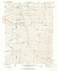 1934 Meramec State Park1962 Print · USGSThe Meramec River valley in the mid-1930s reveals a region transitioning from isolated settlements to a destination for early 20th-century tourism. Genealogists and historians can trace defunct school districts like Pea Ridge Sch and Zion Sch, locate the CCC Camp, or find old river crossings at Hamilton Ford.2 unique versions available
 - 1937 Map of Meramec State Park
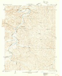 1937 Meramec State Park1937 Print · USGSThe Missouri Ozarks are captured here in the mid-1930s, showing the early infrastructure of Meramec State Park and its surrounding river communities. Genealogists and hikers can trace old homesteads and local landmarks like Reedville Ch, the CCC Camp, and the historic Sappington Bridge river crossing.
End of results
Showing maps 1-2 of 2
Top cities near Sullivan
- Union historical maps
- Saint Clair historical maps
- Cuba historical maps
- Bourbon historical maps
- Gerald historical maps
- Oak Grove Village historical maps
See more
Frequently asked questions
- What are the different types of historical maps available for Sullivan?
- What is the oldest map of Sullivan?
- Where can I purchase historical maps of Sullivan for my home or office?
- Where can I download high-res historical maps of Sullivan?
- Are there historical topographic maps available for Sullivan?
- Is there historical aerial imagery available for Sullivan?
- Where are historical maps of Sullivan sourced from?