1940s Maps of Bado, Missouri
Explore 2 historic maps of Bado from the 1940s. These maps offer a rare glimpse into what life looked like during the 1940s — showing old roads, neighborhoods, homes, and landmarks that have changed or disappeared over time.
Whether you're researching your family's past, planning a metal detecting trip, or studying how Bado's landscape evolved across the 1940s, these high-resolution maps are a powerful tool for exploring the history of this region.
- Focus on a specific era: All maps on this page are from the 1940s, giving you a focused view of this time period.
- See what’s changed: Compare century-old streets, trails, and buildings to today's modern landscape using overlays and satellite layers.
- Research with precision: Use these maps for genealogy, historical research, land use analysis, or educational projects.
- View, download, or print: Maps are fully viewable online in high resolution, and can be downloaded or printed for your own records.
Start exploring Bado's history through authentic maps from the 1940s. This is your window into the past.
Bado, MO maps
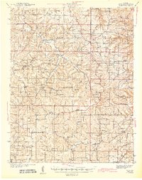
(2)- 1941 Map of Bado, 1974 Print
 1941 Bado1974 Print · USGSTexas County, Missouri, is documented here in the early 1940s, showing a landscape of small upland farms and forest communities. Genealogists can trace family roots through numerous sites like Old Union Cem, Bucyrus, and Pleasant Ridge Sch.
 - 1943 Map of Bado
 1943 Bado1943 Print · USGSThe Missouri Ozarks are captured here in the early 1940s, showing a landscape defined by the Mark Twain National Forest and rural river valleys. Genealogists can trace family roots through numerous landmarks like Lynch Cem, Ragsdale Sch, and the Barium Mine.3 unique versions available
End of results
Showing maps 1-2 of 2
Top cities near Bado
- Cabool historical maps
- Houston historical maps
- Roubidoux historical maps
- Upton historical maps
- Sargent historical maps
Frequently asked questions
- What are the different types of historical maps available for Bado?
- What is the oldest map of Bado?
- Where can I purchase historical maps of Bado for my home or office?
- Where can I download high-res historical maps of Bado?
- Are there historical topographic maps available for Bado?
- Is there historical aerial imagery available for Bado?
- Where are historical maps of Bado sourced from?