1900s (20th Century) Maps of Arthur, Missouri
Explore 9 historic maps of Arthur from the 1900s (20th Century). These maps offer a rare glimpse into what life looked like during the 1900s — showing old roads, neighborhoods, homes, and landmarks that have changed or disappeared over time.
Whether you're researching your family's past, planning a metal detecting trip, or studying how Arthur's landscape evolved across the 1900s, these high-resolution maps are a powerful tool for exploring the history of this region.
- Focus on a specific era: All maps on this page are from the 1900s, giving you a focused view of this time period.
- See what’s changed: Compare century-old streets, trails, and buildings to today's modern landscape using overlays and satellite layers.
- Research with precision: Use these maps for genealogy, historical research, land use analysis, or educational projects.
- View, download, or print: Maps are fully viewable online in high resolution, and can be downloaded or printed for your own records.
Start exploring Arthur's history through authentic maps from the 1900s. This is your window into the past.
Arthur, MO maps
(9)- 1936 Map of Rich Hill
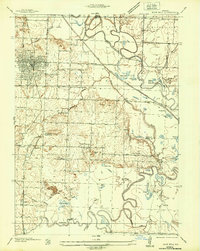 1936 Rich Hill1936 Print · USGSRich Hill and the surrounding river bottoms are captured here in the mid-1930s, during an era of transition for Missouri's coal country. Genealogists and local historians can trace rural school districts like Stone Gate Sch and Panama Sch, or locate family-named sites such as Philbrick Hills and the Jonnum Mines.
 - 1947 Map of Lawrence, 1954 Print
 1947 Lawrence1954 Print · USGSEastern Kansas and western Missouri thrive in the late 1940s, showing a landscape defined by major river valleys and a dense railway network. Genealogists can trace family settlements from Lawrence to Greenwood and locate landmarks like Olathe Navy and Lake Lotawana.
 - 1950 Map of Lawrence
 1950 Lawrence1950 Print · USGSMid-century Kansas and Missouri come alive in this map of the river-valley corridors just as the interstate era was beginning. Researchers can trace the legacy of major rail lines like the Union Pacific RR and locate ancestral roots in towns from Lawrence to Harrisonville.
 - 1955 Map of Rich Hill
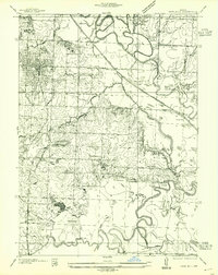 1955 Rich Hill1955 Print · USGSBates and Vernon Counties are captured here in the mid-1930s, showing a landscape shaped by coal mining and river bottomlands. Genealogists can trace rural school districts like Stone Gate Sch and old mining centers at Carbon Center and Monnum Mines.
 - 1956 Map of Lawrence, 1967 Print
 1956 Lawrence1967 Print · USGSEastern Kansas and the Missouri border country are captured here during the mid-century transition to the interstate era. Genealogists and local historians can trace family-named terrain like Summers Mound and the footprint of Sunflower Ordnance Works near Baldwin City.4 unique versions available
 - 1961 Map of Lawrence
 1961 Lawrence1961 Print · USGSThe Kansas-Missouri borderland shows its mid-century transition from a rail-dependent agricultural region to a suburbanizing landscape. Genealogists can trace family footprints through numerous Cem sites and distinctive terrain landmarks like Graves Mound and Summers Mound.
 - 1963 Map of Rich Hill
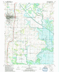
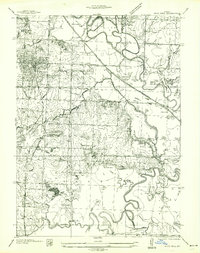 1963 Rich Hill1963 Print · USGSThe confluence of the Osage and Little Osage rivers dominates this Bates County landscape in the mid-1930s. Researchers can locate vanished rural schools like Diamond Sch and Panama Sch or trace the early industrial footprint of Monnum Mines near Carbon Center.
 - 1981 Map of Butler
 1981 Butler1981 Print · USGSWestern Missouri and eastern Kansas settlements are documented here in the early eighties, as the river valleys were transitioning into major wildlife management areas. Genealogists can locate family names near Greenlawn Cem or trace the development of towns like Butler, Osawatomie, and Appleton City.
 - 1991 Map of Rich Hill
 1991 Rich Hill1991 Print · USGSBates and Vernon Counties were captured in the early nineties as a landscape of river bends and rural crossroads. Local historians can trace the foundations of Rich Hill and its surrounding communities, including Panama, Carbon Center, and the Harmony Sch site.
End of results
Showing maps 1-9 of 9
Top cities near Arthur
- Nevada historical maps
- Butler historical maps
- Rich Hill historical maps
- Hume historical maps
- Walker historical maps
- Pleasant Gap historical maps
See more
Frequently asked questions
- What are the different types of historical maps available for Arthur?
- What is the oldest map of Arthur?
- Where can I purchase historical maps of Arthur for my home or office?
- Where can I download high-res historical maps of Arthur?
- Are there historical topographic maps available for Arthur?
- Is there historical aerial imagery available for Arthur?
- Where are historical maps of Arthur sourced from?