1900s (20th Century) Maps of Rayborn, Missouri
Explore 8 historic maps of Rayborn from the 1900s (20th Century). These maps offer a rare glimpse into what life looked like during the 1900s — showing old roads, neighborhoods, homes, and landmarks that have changed or disappeared over time.
Whether you're researching your family's past, planning a metal detecting trip, or studying how Rayborn's landscape evolved across the 1900s, these high-resolution maps are a powerful tool for exploring the history of this region.
- Focus on a specific era: All maps on this page are from the 1900s, giving you a focused view of this time period.
- See what’s changed: Compare century-old streets, trails, and buildings to today's modern landscape using overlays and satellite layers.
- Research with precision: Use these maps for genealogy, historical research, land use analysis, or educational projects.
- View, download, or print: Maps are fully viewable online in high resolution, and can be downloaded or printed for your own records.
Start exploring Rayborn's history through authentic maps from the 1900s. This is your window into the past.
Rayborn, MO maps
(8)- 1931 Map of Manes
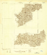 1931 Manes1931 Print · USGSWright and Texas Counties are shown here in the early thirties, a landscape of ridge-top schools and river-valley mills. Researchers can trace rural lineages through local landmarks like Grimes Mill, Post Oak Sch, and Evening Shade Ch.
 - 1941 Map of Manes, 1965 Print
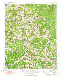 1941 Manes1965 Print · USGSThe northern Ozarks come to life in this mid-century survey of the Gasconade River valley and the surrounding hills of Laclede and Wright counties. Genealogists can trace family footprints through numerous rural landmarks like Grimes Mill, McBride Cem, and the village of Manes.2 unique versions available
 - 1943 Map of Manes
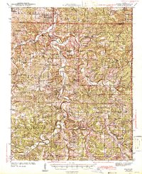 1943 Manes1943 Print · USGSWright and Laclede counties are shown here in the 1940s as a landscape of river-bottom farms and rural school districts. Researchers can trace family ties through dozens of local landmarks like Latham Mill, Competition, and Indian Grove Sch.3 unique versions available
 - 1954 Map of Springfield
 1954 Springfield1954 Print · USGSThe Missouri Ozarks are captured here during the post-war era, showing the expansion of Springfield and the surrounding river valleys. Genealogists and historians can trace local landmarks like Mount Comfort Cemetery and the Fort Leonard Wood military grounds.6 unique versions available
 - 1958 Map of Springfield
 1958 Springfield1958 Print · USGSThe Missouri Ozarks are captured during the mid-century era of growth, centered on the bustling hub of Springfield. Genealogists and historians can trace family roots through numerous landmarks like Ebenezer Church, Stockton Cem, and the various county courthouses.
 - 1959 Map of Springfield
 1959 Springfield1959 Print · USGSThe Missouri Ozarks are captured here during a decade of postwar growth and increasing highway connectivity. Researchers can trace the legacy of the St Louis-San Francisco RR and locate early sites in Springfield, Lebanon, and Mountain Grove.
 - 1983 Map of Mountain Grove
 1983 Mountain Grove1983 Print · USGSWright and Webster counties in the early 1980s show a traditional Ozark landscape of ridge-running railroads and river headwaters. You can trace the Burlington Northern Railroad through towns like Mansfield or find rural landmarks like Vance Cem and Mt Zion Church.
 - 1987 Map of Dawson
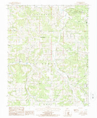 1987 Dawson1987 Print · USGSWright County, Missouri, is captured here in the late eighties as a landscape of remote townships and deep Ozark hollows. Genealogists and local historians can trace the vicinity of Dawson, Graff, and Rayborn along the winding banks of Dove Creek and Beaver Creek.
End of results
Showing maps 1-8 of 8
Top cities near Rayborn
- Cabool historical maps
- Roubidoux historical maps
- Mansfield historical maps
- Hartville historical maps
- Upton historical maps
- Norwood historical maps
See more
Frequently asked questions
- What are the different types of historical maps available for Rayborn?
- What is the oldest map of Rayborn?
- Where can I purchase historical maps of Rayborn for my home or office?
- Where can I download high-res historical maps of Rayborn?
- Are there historical topographic maps available for Rayborn?
- Is there historical aerial imagery available for Rayborn?
- Where are historical maps of Rayborn sourced from?